Rule of marteloio
The rule told mariners how to plot the traverse between two different navigation courses by means of resolving triangles with the help of the Toleta and basic arithmetic.
[7] The "rule of marteloio" was used in European navigation in the Middle Ages, most notably in the Mediterranean Sea between the 14th and 16th centuries, although it may have older roots.
This information was sometimes collected and written down in a pilot's handbook, known as a portolano ("port book", in Italian, equivalent to the Greek periplus, the Portuguese roteiro and the English rutter).
A mariner wishing to sail from Majorca to Naples could tell the latter was due east ("Levante") by some 600 miles – but the island of Sardinia lies in the way, therefore the ship's bearing must be changed along the route.
[11] Islands were a predictable obstacle – circumventing Sardinia would be simply a matter of sailing southeast for a set distance then changing the bearing to northeast ("Greco") for the remainder.
In his Arbor Scientiae (1295), in the section of questions on geometry, Llul writes: How do mariners measure miles at sea (miliaria in mari)?
[18] The Kingdom of Majorca, under Muslim rule until the 1230s, remained a multicultural center in Lull's time, with flourishing Jewish communities, many of whom dabbled in mathematics and astronomy, and whose seafarers had extensive contact across the Mediterranean Sea.
In the first folio of his 1436 portolan atlas, the Venetian captain Andrea Bianco explains the raxon de marteloio, how to calculate the traverse and recover the course.
Once that difference is determined, the second column gives the Alargar (the "Widening", the current distance the ship is from the intended course) while the third column tells the Avanzar (the "Advance", how much of the distance on the intended course has already been covered by sailing on the current bearing – this is equivalent of Ramon Llull's miliaria di mari).
In other words, he needs to hold his ENE bearing for 143 miles; once that distance is traveled, he should straighten his ship east, and he will be exactly back on the intended course.
The sixth and final column (avanzo di ritorno) gives the length on the intended course he has made good by his return travel.
The toleta is a rather simple table, easy to consult and perform calculations with, and sufficiently compact to be memorized by navigators (as Bianco recommends).
While the "rule of three" was already known in the 14th century, skill in executing multiplication and division could be elusive for Medieval sailors drawn from what was a largely illiterate society.
[24] And this kind of mathematics was taught at the abacus schools which were set up in the 13th century in the commercial centers of northern Italy to train the sons of merchants, the very same class where Italian navigators were drawn from.
Taylor notes, "sailors were the first professional group to use mathematics in their everyday work"[25] For those troubled by the high art of manipulating numbers, there was an alternative.
The cherub with the dividers suggests how a navigator is supposed to use the grid to calculate alargar and avanzar by visual measurement rather than manipulating numbers.
Then using a straightedge ruler draws a line up to the East ray, and marks the corresponding spot C. It is easy to see immediately that a right-angled triangle ABC has been created.
The length AC is the avanzar (distance made good), which is 111 miles – visually, five grid squares and a bit, or (20 × 5) + 11, measured by dividers and scale again.
The tondo e quadro device is very similar to the Arab sine quadrant (Rubul mujayyab), with the corner rays replicating the role of the adjustable plumb line.
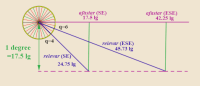
)[31] Example: Suppose a ship sailing NW ("Maestro") spots a landmark due West ("Ponente") one evening, but distance unknown.
Suppose the ship continues sailing on the NW route overnight, and the next morning, 40 miles later, it notices that landmark is now west-southwest (WSW, "Ponente-Libeccio") of its current position.
The way to solve this by the rule of marteloio is to pose the problem in reverse: treat West as intended bearing and SW as the actual course.
In the late 15th and 16th centuries, the improvement of nautical astronomy and the introduction of latitude parallels allowed navigators to determine their position at sea by celestial readings, rather than relying on estimation of distance sailed.
[32] The successor of the rule of marteloio was the "Regiment of the Leagues" (regimento das léguas), that was used by Portuguese navigators sailing in the Atlantic Ocean.
Despite the difference in terminology, notably the use of latitude degrees, the rule of marteloio and the Regiment of the Leagues are very similar – they are both about solving triangles on a plane chart.
The advantage of the regiment over the marteloio is the introduction of latitude parallels in the table, so that the position can be checked by astronomical observation (via quadrant, astrolabe, etc.
For instance, the search for the Todesillas line (meridian 370 leagues west of Cape Verde) is much simplified by reference to a precise latitude.
[39] In marteloio language, when "resolving the traverse", the known information given is the "actual course" and the "ritorno", while the unknowns are the "intended bearing" and "total avanzo".
Or, even more simply, calculate θ as the angle of difference from the nearest principal wind (N, S, E, W), run the formulas and then place the larger number in the appropriate column (D.Lat.
[40] Ramon Llull's suggestive 1295 remarks aside, the earliest known reference to marteloio is dated 1390, in the inventory of the estate of the mother of a certain Oberto Foglieto of Genoa, where an entry reads unum martelogium....item carta una pro navegando.