St. Lawrence River
The river remains an important shipping route as the backbone of the St. Lawrence Seaway, a lock and canal system that enables world marine traffic to access the inland ports of the Great Lakes Waterway.
The prevailing winds and currents push this ice towards the estuary,[15] and it reaches the east of Les Méchins at the end of December.
[16] With the draining of the Champlain Sea, due to a rebounding continent from the Last Glacial Maximum, the St. Lawrence River was formed.
[19] Today, the St. Lawrence River begins at the outflow of Lake Ontario and flows adjacent to Cape Vincent, Gananoque, Clayton, Alexandria Bay, Brockville, Morristown, Ogdensburg, Massena, Cornwall, Montreal, Trois-Rivières, and Quebec City before draining into the Gulf of St. Lawrence, often given as the largest estuary in the world.
Lake Champlain and the Ottawa, Richelieu, Saint-Maurice, Saint-François, Chaudière and Saguenay rivers drain into the St. Lawrence.
According to the United States Geological Survey, the St. Lawrence Valley is a physiographic province of the larger Appalachian division, containing the Champlain section.
tributary The diversity of the St. Lawrence River includes:[27] Large marine mammals travel in all the seas of the earth, the research and observations of these giants concern fishermen and shipping industry, exercise a fascination and a keen interest for laymen and, subjects of endless studies for scientists from Quebec, Canada and around the world.
[29][30][31] Thirteen species of cetaceans frequent the waters of the estuary and the Gulf of St. Lawrence:[32] Flowing through and adjacent to numerous Indigenous homelands, the river was a primary thoroughfare for many peoples.
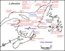
Beginning in Dawnland at the Gulf of St. Lawrence, the river borders Mi'kma'ki[37] in the South (what is today known as the Canadian Maritimes), and Nitassinan in the North, the national territory of the Innu people.
[39] Continuing, the river passes through the former country of the St. Lawrence Iroquois and then three of the six homelands of the Haudenosaunee: the Mohawk or Kanienʼkehá꞉ka, the Oneida or Onyota'a:ka, and the Onondaga or Onöñda’gaga’.
[40][41] Nionwentsïo occupies both the north and south shores of the river,[40] overlapping with Nitassinan and the more western Wabanaki or Dawnland countries.
[39] The Norse explored the Gulf of St. Lawrence in the 11th century and were followed by fifteenth- and early sixteenth-century European mariners, such as John Cabot, and the brothers Gaspar and Miguel Corte-Real.
At that time, the land along the river described as "about two leagues, a mountain as tall as a heap of wheat" was inhabited by the St. Lawrence Iroquoians.
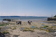
[46] The earliest regular Europeans in the area were the Basques, who came to the St Lawrence Gulf and River in pursuit of whales from the early 16th century.
The Basque whalers and fishermen traded with indigenous Americans and set up settlements, leaving vestiges all over the coast of eastern Canada and deep into the St. Lawrence River.
British troops were ferried via the St. Lawrence to attack the city from the west, which they successfully did at the Battle of the Plains of Abraham.
In 1809, the first steamboat to ply its trade on the St. Lawrence was built and operated by John Molson and associates, a scant two years after Fulton's steam-powered navigation of the Hudson River.