San Bernardino, California
Serrano and Cahuilla people inhabited Politana until long after the 1830s decree of secularization and the 1842 inclusion into the Rancho San Bernardino land grant of the José del Carmen Lugo family.
Some Mormons would stay in San Bernardino and some later returned from Utah, but a real estate consortium from El Monte and Los Angeles bought most of the lands of the old rancho and of the departing colonists.
They sold these lands to new settlers who came to dominate the culture and politics in the county and San Bernardino became a typical American frontier town.
According to the Native American legend regarding the landmark arrowhead, an arrow from Heaven burned the formation onto the mountainside in order to show tribes where they could be healed.
During the mid-19th century, "Dr." David Noble Smith claimed that a saint-like being appeared before him and told of a far-off land with exceptional climate and curative waters, marked by a gigantic arrowhead.
Indigenous people of the San Bernardino Valley and Mountains were collectively identified by Spanish explorers in the 19th century as Serrano, a term meaning highlander.
[16] Yuhaviatam leader Santos Manuel guided his people from their ancient homeland to a village site in the San Bernardino foothills.
In 1883, California Southern Railroad established a rail link through San Bernardino between Los Angeles and the rest of the country.
The particularly arid climate during the summer prevents tropospheric clouds from forming, meaning temperatures rise to what is considered by NOAA scientists as Class Orange.
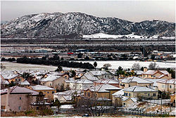
Arrowhead Springs, San Bernardino's northernmost neighborhood gets snow, heavily at times, due to its elevation of about 3,000 feet (910 m) above sea level.
The seasonal Santa Ana winds are felt particularly strongly in the San Bernardino area as warm and dry air is channeled through nearby Cajon Pass at times during the autumn months.
This phenomenon markedly increases the wildfire danger in the foothills, canyon, and mountain communities that the cycle of cold, wet winters and dry summers helps create.
According to the 2010 United States Census, San Bernardino had a median household income of $39,097, with 30.6% of the population living below the federal poverty line.
[39] Some Asian Americans live in and around the city of San Bernardino, as in a late 19th-century-era (gone) Chinatown and formerly Japanese-American area in Seccombe Park on the east end of downtown, and a large East-Asian community in North Loma Linda.
[43] According to 2022 American Community Survey, English ancestry is 4.2%, French (except Basque) is 0.9%, German 4.6%, Irish is 3.9% Italian, 2.1% Norwegian, 0.6%Polish, 0.6%Scottish 0.7% and Subsaharan African - 0.8%.
[45] The city's location close to the Cajon and San Gorgonio passes, and at the junctions of the I-10, I-215, and SR-210 freeways, positions it as an intermodal logistics hub.
Large warehouses for Kohl's, Mattel, Pep Boys, and Stater Bros. have been developed near the San Bernardino International Airport.
[46] The closing of Norton Air Force Base in 1994 resulted in the loss of 10,000 military and civilian jobs and sent San Bernardino's economy into a downturn that has been somewhat offset by more recent growth in the intermodal shipping industry.
Long the headquarters for Campus Crusade for Christ, the site now remains largely vacant and unused since their operations moved to Florida.
The California State University, San Bernardino (CSUSB) Coyotes compete at the NCAA Division II level in a variety of sports.
Perris Hill Park is the largest with Roosevelt Bowl, Fiscalini Field,[63] several tennis courts, a Y.M.C.A., a senior center, a shooting range, hiking trails, and a pool.
[65] The current city council is made up of Theodore Sánchez, Sandra Ibarra, Juan Figueroa, Fred Shorett, Ben Reynoso, Kim Calvin-Johnson and Damon L.
[75] Police efforts have significantly reduced crime in 2008[76] and a major drop collectively since 1993 when the city's murder rate placed ninth in the nation.
[77] Thirty two killings occurred in 2009, a number identical to 2008 and the lowest murder rate in San Bernardino since 2002, but only a third of cases led to arrests.
[80] On July 10, 2012, the City Council of San Bernardino decided to seek protection under Chapter 9, Title 11, United States Code, making it the third California municipality to do so in less than two weeks (after Stockton and the town of Mammoth Lakes), and the second-largest ever.
KPXN, the Los Angeles Ion Television network affiliate, is licensed to San Bernardino, but the station maintains no physical presence there.
A bus rapid transit corridor, called the sbX Green Line, connects the north part of the city near California State University, San Bernardino and the Verdemont Hills area with the Jerry L. Pettis VA Medical Center in Loma Linda, CA.
The San Bernardino Transit Center in the downtown area is where passengers can connect with the sbX Green Line BRT, and regular bus service from MARTA, Omnitrans, and VVTA.
Trains begin at the San Bernardino Transit Center and make an additional stop at Tippecanoe Avenue before continuing into Redlands.
San Bernardino International Airport is physically located within the city and provides commercial passenger air service.