Las Vegas Valley
The state's largest urban agglomeration, the Las Vegas Metropolitan Statistical Area is coextensive since 2003 with Clark County, Nevada.
In its relatively short history, it has established a diverse presence in international business, commerce, urban development, and entertainment, as well as one of the most visited tourist attractions destinations in the world.
In 2014, a record-breaking 41 million people visited the Las Vegas area, producing a gross metropolitan product of more than $100 billion.
[10][11][12] Las Vegas was named by Mexicans in the Antonio Armijo party,[4] including Rivera, who used the water in the area while heading north and west along the Old Spanish Trail from Texas.
[11] The area was previously settled by Mormon farmers in 1854 and later became the site of a United States Army fort in 1864, beginning a long relationship between southern Nevada and the U.S. military.
Since the 1930s, Las Vegas has generally been identified as a gaming center as well as a resort destination, primarily targeting adults.
Businessman Howard Hughes arrived in the late 1960s and purchased many casino hotels, as well as television and radio stations in the area.
Legitimate corporations began to purchase casino hotels as well, and the mob was run out by the federal government over the next several years.
The constant stream of tourist dollars from the hotels and casinos was augmented by a new source of federal money from the establishment of what is now Nellis Air Force Base.
Notable exclusions from the "Urban Planning Area" include Red Rock, Blue Diamond, and Mount Charleston.
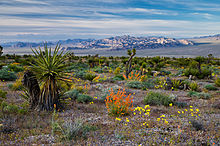
A "distorted surface",[23] a playa-like region, occurs at the farthest northwest area, for about 15 to 18 miles (24 to 29 km), starting from Nevada Route 157.
The Corn Creek Dunes lie about 5 miles (8.0 km) southwest of Route 156's intersection with U.S. 95, and they are slightly northeast of Las Vegas Wash.
[27] Very low humidity, however, tempers the effect of these temperatures, though dehydration, heat exhaustion, and sun stroke can occur after even a limited time outdoors in the summer.
The interiors of automobiles often prove deadly to small children and pets during the summer and surfaces exposed to the sun can cause first- and second-degree burns to unprotected skin.
July and August can also be marked by monsoon season, when moist winds from the Gulf of California soak much of the Southwestern United States.
Since manufacturing is not a dominant industry of Las Vegas, and with Clark County working to control air quality problems, success has been shown over the years.
Now shopping, conventions, fine dining, and outdoor beauty [clarification needed] are also major forces in attracting tourist dollars.
[39] While Las Vegas has historically attracted high-stake gamblers from around the world, it is now facing tougher competition from the UK, Hong Kong and Macau (China), Eastern Europe and developing areas in the Middle East.
While the cost of housing spiked up over 40% in 2004, the lack of business and income taxes still makes Nevada an attractive place for many companies to relocate to or expand existing operations.
Being a true twenty-four-hour city, call centers have always seemed to find Las Vegas a good place to hire workers who are accustomed to working at all hours.
[45] It put a massive strain on the construction ability and workforce of the area due to number of laborers and amount of materials required.
The Las Vegas Valley is home to various suburban master planned communities that include extensive recreational amenities such as lakes, golf courses, parks, bike paths and jogging trails.
Planned communities in the valley include Aliante, Anthem, Cadence, Centennial Hills, Green Valley, Inspirada, Lake Las Vegas, The Lakes, Mountain's Edge, Peccole Ranch, Providence, Rhodes Ranch, Seven Hills, Skye Canyon, Southern Highlands, and Summerlin.
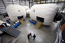
[further explanation needed] Some current technology companies in southern Nevada include: Bigelow Aerospace, Petroglyph, Switch Communications, US Support LLC, Fanatics, and Zappos.
In 2015, Electric vehicle startup Faraday Future has chosen North Las Vegas's Apex Industrial Park for its $1 billion car factory.
The monorail, lying somewhat east of the Strip, facilitates north–south travel, including stations at several casinos and the Las Vegas Convention Center.
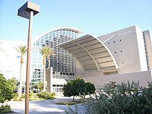
The center is appropriate for Broadway shows and other major touring attractions as well as orchestral, opera, choir, jazz, and dance performances.
The Las Vegas Natural History Museum features robot dinosaurs, live fish, and more than 26 species of preserved animals.
I-11 goes northwest to the Las Vegas Paiute Indian Reservation and southeast to Henderson, bypassing downtown Boulder City just to the south, and then to the Mike O'Callaghan–Pat Tillman Memorial Bridge over the Colorado River, from there U.S. Route 93 continues towards Phoenix, Arizona.
US 93 splits from I-15 northeast of Las Vegas and goes north through the northeastern part of the state, serving Ely and Wells and US 95 heads south from I-11 and US 93 in Boulder City through far southeastern California.