San Lorenzo Tenochtitlán
The earliest evidence for Olmec culture is found at nearby El Manatí, a sacrificial bog with artifacts dating to 1600 BCE or earlier.
Another term archaeologists use is for categorizing the Olmecs is the Formative Period, meaning the pivotal years that laid the ground work for state-level complex societies.
In contrast to La Venta's swamp-like environs, San Lorenzo was situated in the midst of a large agricultural area.
[3] San Lorenzo seems to have been largely a ceremonial site, a town without city walls, centered in the midst of a widespread medium-to-large agricultural population.
[5] Built on some 700 hectares (1,700 acres) of high ground between then-active tributaries, the core of San Lorenzo covers 55 hectares (140 acres)[6] that were further modified through extensive filling and leveling; by one estimate 500,000 to 2,000,000 cubic metres (18,000,000 to 71,000,000 cu ft) of earthen fill were needed, moved by the basketload.
Residents of San Lorenzo also consumed domestic dog, snook, tarpon, mojarra, catfish, and turtles.
[8] San Lorenzo also boasted an elaborate drainage system which used buried, covered, channeled stones as a type of "pipe".
[12] Between 1946 and 1970, four archaeological projects were undertaken, including one Yale University study headed by Michael Coe and Richard Diehl conducted between 1966 and 1968, followed by a lull until 1990.
The name "San Lorenzo Tenochtitlán" was coined by Stirling in 1955, taken from the nearby present-day villages, and refers to the entire complex of sites.
Matthew Stirling gave the name San Lorenzo Tenochtitlan to a cluster of three settlements on an island in the swamps and marshes west of the Coatzacoalcos.
San Lorenzo proper occupies the slopes and summit of a plateau that rises 50 m above the floodplain of the Coatzacoalcos River.
The archaeological site of Tenochtitlán lies within the modern village of the same name at the northern end of the island, and Potero Nuevo occupies a hill east of the plateau.
Another large site occupies the Loma del Zapote, a long ridge extending southward from the plateau, which includes the locality known as El Azuzul at its southern tip.
It also showed the power the rulers had, because a successfully delivery of a stone or finished sculpture involved complex organization and the ability to order extreme amounts of labor.
[1] In the 1960s, Michael Coe and Richard Diehl conducted excavations on San Lorenzo and surrounding sites, and defined eight major phases of occupation.
300–50 BCE), and while there was occupation in the surrounding area during the Early and Middle Classic periods, the site itself was not reoccupied until late in the Villa Alta phase (800–1000 CE).
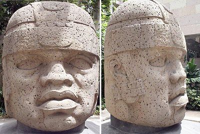
[11] At the top of the plateau of San Lorenzo, massive thrones, colossal heads, and smaller sculptures of humans, felines, birds, and supernatural monsters proclaimed the power of its rulers and its sacred source.
The elites of San Lorenzo lived in large structures raised on low clay platforms amid the monuments that legitimized their authority.
An elite residence named the "Red Palace" had earthen walls and floors, which were plastered with sand stained by hematite.
Evidence shows that the rivers of the region did change course at the time; that may have initiated or exacerbated other problems at the site of San Lorenzo.