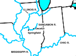
Sangamon River
The section of the Sangamon River that flows through Robert Allerton Park near Monticello was named a National Natural Landmark in 1971.
The river rises from several short headstreams in southern McLean County that arise from a glacial moraine southeast of Bloomington-Normal, Illinois.
This lake, formed by damming the main stem of the river, with no control over upstream land uses, has had major problems with siltation and agricultural pollution.
[4] The upper Sangamon, between Mahomet and Monticello, runs along the face of a terminal moraine within the Lake Michigan Glacial Lobe, which ranges in age from 28,000 to 12,000 BP.
Along this stretch, the eastern part of the watershed of the Sangamon therefore consists of short creeks, two to three miles (3–5 km) in length, that drain the face of the moraine.
In the middle 18th century, the region near the river was the scene of a conflict between the Illini and Meskwaki as part of the larger French and Iroquois Wars.
Groups of Cumberland Presbyterians settled the river valley beginning in 1825, giving the region a distinctive culture identified and described at the turn of the 20th century by Edgar Lee Masters.
Abraham Lincoln arrived with his family in the area in 1830 to settle a section of government land bisected by the river.