Scarborough Shoal
The atolls' status is often discussed in conjunction with other territorial disputes in the South China Sea, such as those involving the Spratly Islands and the 2012 Scarborough Shoal standoff.
[14] "Were any island within those described bounds ascertained to belong in fact to Japan, China, Great Britain or Holland, the United States could derive no valid title from its ostensible inclusion in the Spanish cession.
It was ruled by the Permanent Court of International Justice (PCIJ) that the Norwegian proclamation on July 10, 1931, annexing Eastern Greenland was the "critical date" in that case.
The ICJ ruled that uti possidetis juris is a "general principle, which is logically connected with the phenomenon of the obtaining of independence, wherever it occurs.
Its obvious purpose is to prevent the independence and stability of new States being endangered by fratricidal struggles provoked by the challenging of frontiers following the withdrawal of the administering power…Its purpose, at the time of the achievement of independence by the former Spanish colonies of America, was to scotch any designs which non-American colonizing powers might have on regions which had been assigned by the former metropolitan State to one division or another, but which were still uninhabited or unexplored.
[28]: 9 China said that it has a Yuan dynasty map and subsequent surveys by the royal astronomer Guo Shoujing during Kublai Khan's reign showing that Scarborough Shoal had been used by Chinese fishermen since the 13th century.
[29][30] According to Filipino judge Antonio Carpio, maps of ancient China show the island of Hainan as the southernmost point of the country.
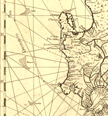
[d] In 1771, Jean Baptiste Nicholas D. D'Apre de Mannevillette published a map of the China Sea which includes Scarborough Shoal, along with Galit, Panacot.
The survey, Plano de la Navigacion, was taken by Alejandro Malaspina aboard the ship Santa Lucía, with Filipino comrades.
[43] In 1808, the Spanish colonial government published the 1808 Carta General del Archipelago Filipino, showing the sovereign territory of the Philippines, which according to the Phlippines included Scarborough Shoal and the Spratly islands, as recognized by the international community.
In 1875, a more complete edition of the Carta General del Archipelago Filipino was published by the Spanish colonial government as the official territory of the Philippines.
[49]: 8 [50] International salvage litigation resulting from the wreck of the Swedish ship Nippon on 8 May 1913, on Scarborough Shoal, was heard and recognised by the claimants in the Philippines.
[55] In an article from 18 February 1980, the Beijing Review confirmed that Guo Shoujing built an observatory in the Paracel Islands, and not Scarborough Shoal.
The parts of the lighthouse had been fabricated on the mainland Philippines but, according to Almontre, the project was scuttled for internal political reasons and to avoid antagonizing the Chinese.
[citation needed] In January 2013, the Philippines formally initiated arbitration proceedings against China's claim on the territories within the "nine-dash line" that includes Spratly Islands and Scarborough Shoal, which it said is "unlawful" under the United Nations Convention on the Law of the Sea (UNCLOS).
[71] On 14 June 2018, China's destruction of Scarborough Shoal's reefs surged to an extent which they became visible via satellites, as confirmed by the University of the Philippines Diliman.
[74] PCG spokesperson Commodore Jay Tarriela later said the water cannon incident was not an "armed attack" that could trigger the US-Philippines Mutual Defense Treaty as there was no "death of a soldier or a member of the Philippine Coast Guard", citing Bongbong Marcos' earlier statement.
[75] A March 2016 article by the Center for Strategic and International Studies' Asia Maritime Transparency Initiative said that satellite imagery had shown no signs of any land reclamation, dredging or construction activities in Scarborough shoal and the only vessels present were a Chinese civilian ship anchored within the mouth of the lagoon, which has been typical for several years, and two Filipino trimaran-type fishing ships outside the shoal.
[76] However, according to the then U.S. chief of naval operations Admiral John Richardson that did not mean that Chinese ships had not performed surveys in preparation for reclamation.
[78] Also in September 2016, the New York Times reported that PRC activities at the Shoal continued in the form of naval patrols and hydrographic surveys.
[79] In March 2017 the mayor of Sansha City said China was to begin preparatory work for an environmental monitoring station on Scarborough Shoal.
[87] An article published in May 2012 in the People's Liberation Army Daily states that Chinese astronomer Guo Shoujing went to the island in 1279, under the Yuan dynasty, as part of an empire-wide survey called "Measurement of the Four Seas" (四海測驗).
[88] In 1979 historical geographer Han Zhenhua (韩振华) was among the first scholars to claim that the point called "Nanhai" (literally, "South Sea") in that astronomical survey referred to Scarborough Shoal.
[93][94] a 2019 article in the publication Maritime Issues suggested that a common fishing ground for China, Vietnam and the Philippines as the best option to avoid deterioration of the conflict.
The Chinese government position paper surprised the Filipino delegation, prompting Carpio to say that China likely did not read the full texts of the treaties they used in court.
It also asserts that the Philippine and US Naval Forces have used it as impact range and that its Department of Environment and Natural Resources has conducted scientific, topographic and marine studies in the atoll, while Filipino fishermen regularly use it as fishing ground and have always considered it their own.
The 18th-century map Carta hydrographica y chorographica de las Islas Filipinas (1734) shows 3 atolls Galit, Panacot and Lumbay.
In 1792, another map drawn by the Malaspina expedition and published in 1808 in Madrid, Spain also showed Bajo de Masinloc as part of Philippine territory.
Many analysts consider that the 1900 Treaty of Washington concerned only the islands of Sibutu and Cagayan de Sulu.,[120][121] but a point of view argued that Scarborough Shoal has been transferred to the United States based on the Treaty of Washington (1900),[122] ignoring the fact that the cession documents from the United States to the Philippines did not have any reference to the Scarborough Shoal.
1599 issued on 11 June 1978 claimed an Exclusive Economic Zone up to 200 nautical miles (370 km) from the baselines from which their territorial sea is measured.