Schuylkill and Susquehanna Navigation Company
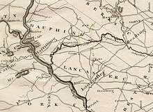
This would have required a four-mile summit crossing between Tulpehocken and the Quittapahilla with an artificial waterway connecting two separate river valleys; namely the Susquehanna and the Schuylkill watersheds.
Philadelphia's dismal failure to build the "golden link" thirty years before New York opened the Erie Canal was a major factor in that slide into second place.
[7] In March, the committee was tasked with preparing a "scheme of application" for the Philadelphia merchants for defraying the expenses of conducting a route location ("proper levels") for the canal as well as construction costs.
[7] That same month, Thomas Gilpin, a member of the merchant committee, submitted an alternative "plan of a canal and elevation" using the original southerly route along the Chester River and Duck Creek.
[6][10] The Pennsylvania Provincial Assembly then appointed a committee of its own to survey the Susquehanna, Schuylkill, and Lehigh Rivers and in 1773, David Rittenhouse delivered its report.
[3][6] The project became the goal of the Society for the Improvement of Roads and Inland Navigation[5] organized in 1789 with preeminent, wartime financier Robert Morris[10] as president, David Rittenhouse, William Smith and John Nicolson.
[15] The proposed mileages were:[16] The concept of navigation in the context of the post-colonial United States and 1790 timeframe was predominately focused on improving river systems.
[15] A contemporary project, the Western Inland Lock Navigation Company in New York which later became a part of the Erie Canal was also "... primarily a river system.
"[15] In the Pennsylvania scheme, large rivers such as the Susquehanna and to a lesser extent, the Schuylkill were to be improved by clearing channels through obstructions and building dams where needed.
While the Society mapped the prospective route with commendable diligence and care, its efforts were of course immeasurably handicapped by a lack of knowledge of canals which at that time were unknown in America but upon which the surveys of the board of commissioners indicated the waterway would have to depend for a short distance in the eastern region and perhaps in the vicinity of the Allegheny Mountains.
"It is supposed that the canal or lock navigation between the heads of Tulpehocken and Quitapahilla, is to be compleated; but if that work should be thought too great to begin with, it will be only the addition of four miles portage, by an excellent and level road."
[21] At the time that Robert Morris and the others were organizing the company "(p)oor harvests in Europe brought unprecedented agricultural and commercial prosperity to the Delaware Valley.
"[30] One of the administration's first official acts as part of Hamilton's economic plan was to "...pour thousands of dollars into the pockets of prescient speculators by funding depreciated American bonds at 100 percent of their face value.
[34] "Pennsylvania's backlands ... (were) ... the stakes in a giant speculative bubble: they were cheap, they could be bought on credit, they could be paid for in depreciated certificates, settlement and improvement requirements were generally overlooked, and those in actual charge of the disposal of lands were very cooperative.
A four-mile summit crossing between Tulpehocken and the Quitipahilla would be an artificial waterway connecting two separate river valleys; namely the Susquehanna and the Schuylkill watersheds.
[40] by 1885, the Union canal was sold at a sheriff sale, "unable to cope with ... (competition from) ... the railroads, poor planning, and the carbonate bedrock of Lebanon County, Pennsylvania.
[9] Nonetheless, the Navigation company hired Brindley in April 1792 for the construction season work as canal engineer along with Col. Thomas Bull (1744-1837) as superintendent.
[13] In May, the board of directors with Brindley tour the summit crossing between the Quitapahilla and Tulpehocken Creeks as well as the waters to the north, including the Deep Run Branch of the Little Swatara.
[13] Based solely upon Brindley's work and before their new British engineer, Weston could review the scheme, in October 1792, the Board authorized Superintendent Bull to purchase a strip of land 100 feet wide for the canal route to the Swatara.
In October 1792, the Board of Directors appointed a committee to "... confer with the Delaware & Schuylkill Canal and Philadelphia & Lancaster Turnpike Road on sending a joint agent to New England to recruit labor.
More importantly, the Board also directs Bull to negotiate "... an agreement with the Delaware & Schuylkill Canal and the Philadelphia & Lancaster Turnpike Road to observe a uniform ceiling on the wages to be offered.
"[13] The joint committee also agreed to "... cooperate with each other and with local employers of day laborers so as not to increase wages by bidding against each other; workers imported from New England are to be excepted.
"[13] Brindley's design concept for the summit crossing was a cut twenty-five deep, thirty-feet wide at the bottom and watered to a depth of four feet.
"[13] In 1794, as part of the federal government's response to the Whiskey Rebellion, George Washington, according to historian Joseph Ellis, became "the first and only time a sitting American president led troops in the field".
[47] On the second of October, 1794, Washington left Reading heading west to Womelsdorf in order to "view the canal from Myerstown towards Lebanon and the locks between the two places ...".
[47] Another officer on the march noted that at that time, ten miles of canal had been excavated and five locks constructed for a total lift of thirty feet in elevation.
In 1807, Charles Gottfried Paleske (1758-1816) was elected to the Board of Directors of the company and working with James Milnor, Robert Brooke, Isaac Roberdeau, and John Scott walked "... the line of the Schuylkill & Susquehanna Navigation Company from Kruitzer's plantation where the canal ends to the end of the summit near Kucher's mill, about 9 miles; find the work in good condition including the five locks at Ley's, and the bridges decayed or collapsed ..."[48] In 1808, Paleske was elected president and Joseph S. Lewis (1778-1836) treasurer.
[48] In 1810, William John Duane (1780-1865) writing as "Franklin" advocates for reviving the Schuylkill and Susquehanna Navigation company as part of a scheme for a canal route to Lake Erie instead of the Ohio Valley.
[51] Pennsylvania however, was so situated physiographically that most of its trade was carried out of the State away from its chief city and the Federal capital, Philadelphia by its two rivals; Baltimore at the base of the Susquehanna system and Albany on the north.
[51] Throughout this period, it was argued by men such as Samuel Breck and William Duane that connecting the Schuylkill and Susquehanna rivers would solve all these problems and assure Philadelphia that its trade would be secured and enlarged.