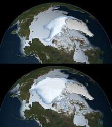
Sea ice concentration
Measurements from ships and aircraft are based on simply calculating the relative area of ice versus water visible within the scene.
Both synthetic aperture radar and visible sensors (such as Landsat) are normally high enough resolution that each pixel is simply classified as a distinct surface type, i.e. water versus ice.
Since SAR images are normally monochrome and the backscatter of ice can vary quite considerably, classification is normally done based on texture using groups of pixels—see pattern recognition.
SSMR and SSMI radiometers were flown on the Nimbus program and DMSP series of satellites.
If we form a vector space from each of the instrument channels in which all but one of the signatures of the different surface types are linearly independent, then it is straightforward to solve for the relative concentrations: where
The NASA team algorithm, for instance, works by taking the difference of two channels and dividing by their sum.
[6] [7] Accuracies of sea ice concentration derived from passive microwave sensors may be expected to be on the order of 5\% (absolute).
[6] [8] [9] A number of factors act to reduce the accuracy of the retrievals, the most obvious being variations in the microwave signatures produced by a given surface type.
This is normally because of its high salt content, not because of radiation being transmitted from the water through the ice—see sea ice emissivity modelling.
Adverse weather conditions, clouds and humidity in particular, will also tend to reduce the accuracy of retrievals.