Sedimentary budget
Sedimentary budgets are a coastal management tool used to analyze and describe the different sediment inputs (sources) and outputs (sinks) on the coasts, which is used to predict morphological change in any particular coastline over time.
These inputs and outputs of sediment then equate to the total balance of the system and more than often reflect the amounts of erosion or accretion affecting the morphology of the coast.
In 1966, Bowen and Inman defined a littoral cell and separated sediment inputs, accretion by longshore drift and outputs.
[5] In order to understand the sedimentary budget of a coastal environment it is important to know the different types of feedback that can determine whether there is stability.
When a beach environment is effected by wind, wave and tidal energy it responds with either positive or negative feedback which determines whether the system is balanced and in equilibrium.
A coastal environment in equilibrium is able to dissipate or reflect incoming energy without the occurrence of sediment input or output and change to morphology.
For example; when a beach in equilibrium erodes during a storm it forms an offshore bar that in turn forces waves to break over it.
[2] In contrast positive feedback pushes a coastal system away from equilibrium by modifying its morphology until a threshold is reached, whereby a different type of response occurs.
For example; if a storm event was to breach the foredune of a beach that is not in equilibrium, a vulnerable area would be created, which in turn would become susceptible to the formation of a blowout due to wind exploiting the absence of vegetation.
Boundaries of littoral cells have been defined using tracer studies of sediment movement, geomorphological observation and sedimentological description, heavy mineral sourcing, and analysis of the spatial distribution of wave flux along the shore.
Prior to the construction of the Aswan Dam, the Nile River delivered 60-180 million tonnes of sediment and water to the Mediterranean Sea every year.
For example; approximately 300,000 m3 of gravel is extracted from the San Luis Rey River in South California every year, which is almost 50 times more than the bedload sediment yield after the dam was built.
For example; in Westland New Zealand this has had a cumulative effect with clear felling of trees increasing in river sediment yield up to eight times.
[10] Sea cliff erosion is a large source of sediment to many coastal sedimentary budgets, initiated by many different processes including wave attack, rainfall and groundwater seepage.
[12] Although less frequently observed than river transport and sea cliff erosion, storms may account for a large percentage of coastal sedimentary budgets.
For salt marsh wetlands, particularly those of coastal Louisiana, sediment accumulation from hurricanes is "sufficient" to account for the entire inorganic sedimentary budget.
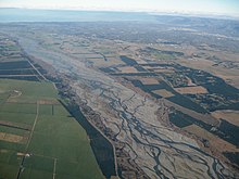
[12] In contrast the Canterbury Bight has a combination of high energy environments and strong southern longshore currents that transport large amounts of sediment north, which can be classified as a sink, putting a deficit to the coasts sedimentary budget.
Models have been developed for measuring longshore drift which can assist in determining a sedimentary budget, if they are integrated over the correct timescale.
An example of this is at Mount Maunganui beach in the North Island of New Zealand which had been experiencing erosion, resulting in coastal dune retreat of almost 20 m. When ongoing dredging at the entrance to the Tauranga Harbour began, it was decided that the sediment removed would be used to re-nourish the Mt.
Being able to incorporate the sedimentary budget into a coastal management plan is becoming critical, especially in today's world where the majority of populations are living and owning property very close to the coast.