Hurricane Rita
In Louisiana, Rita's storm surge inundated low-lying communities along the entire coast, worsening effects caused by Hurricane Katrina less than a month prior, such as topping the hurriedly-repaired Katrina-damaged levees at New Orleans.
Parishes in Southwest Louisiana and counties in Southeast Texas where Rita made landfall suffered from severe to catastrophic flooding and wind damage.
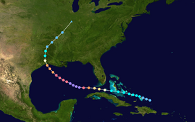
At roughly the same time, a remnant surface trough had developed from a dissipating stationary front and began to drift westward north of the Lesser Antilles.
[3][8] However, an increase in moderate southerly vertical wind shear as the result of a nearby upper-level low subdued continued intensification and displaced convective activity to the north of Rita's center of circulation.
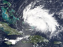
[3][9] Upon entering the Straits of Florida on September 20, Rita strengthened into a Category 1 hurricane by 12:00 UTC,[10] while maintaining a minimum barometric pressure of 985 mbar (hPa; 29.09 inHg).
[3] Aided by favorable outflow and anomalously warm sea surface temperatures (SSTs), the trend of rapid deepening continued,[11] and Rita reached Category 3 status upon entering the Gulf of Mexico by 06:00 UTC on September 21, making it a major hurricane.
Proceeding northward roughly parallel to the state border between Louisiana and Texas,[3] radar imagery indicated that the storm soon lacked winds of tropical storm-force.
Therefore, the NHC classified the system as a tropical depression while it was over Arkansas by 06:00 UTC on September 25,[17] shortly before it turned northeastward ahead of an approaching frontal boundary.
Most residents followed the recommendations of their respective officials, hitting the road by the deadline, though many returned home and waited until early the next morning after encountering severe traffic delays.
27 "Gibbstown Bridge" that crosses the Intracoastal Canal into Lower Cameron Parish two days later in preparation of damage inspection and rescue of any stranded or injured residents, no one was known to have remained.
[46] Nonetheless, many residents remained in the county because they were either unaware of the danger of the storm or believed that it was more important to protect their belongings, particularly in the wake of looting following Hurricane Katrina.
[48] Officials of Harris County hoped that the designation of zones A, B, and C would help prevent bottlenecks in traffic leaving the area similar to those seen at New Orleans prior to Katrina and Hurricane Dennis earlier that year.
[50] Also, people in certain zones were to be forced to go to certain cities in Texas and were not allowed to exit their designated routes except for food and gas – another feature of the evacuation plan which officials hoped would keep traffic flow orderly.
[52] After heavy traffic snarled roads leading out of town and gas shortages left numerous vehicles stranded, Mayor White backed off his earlier statement with, "If you're not in the evacuation zone, follow the news," advising people to use common sense.
[54] During the Rita evacuation, these preparations and their execution were overwhelmed by the enormous and unprecedented number of people fleeing from the Houston area prior to the departure of local residents.
[64] In June 2009, nearly four years after the fire, families of those who died in the accident won an $80 million settlement against the manufacturer of the bus and the company that provided the nursing home with it.
[84] Tropical storm-force winds were primarily limited to the northern coasts of Cuba's western provinces, with heavy rainfall extending into interior portions of the country.
[90] Rough surf generated by Rita later caused minor to moderate beach erosion along the coast of the Florida Panhandle on September 22, including Franklin, Taylor, Walton, and Wakulla counties.
[3][75][105] Farther inland, tropical storm-force wind gusts affected northwestern Louisiana, strong enough to knock down trees and power lines, which damaged homes and vehicles.
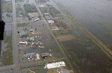
There was extensive minor-to-major structural wind damage across the entire area, including the near-devastation of the Lake Charles Regional Airport south of the city.
[110] Damage to the entire region's electrical and communications infrastructure was severe, and authorities warned returning residents that restoration of services to some areas would take weeks to months.
In Vermilion Parish east of its landfall location, Rita's storm surge damaged dozens of homes and businesses, including most of the structures on Pecan Island.
Closer to the Intracoastal Waterway, communities shared a similar fate; Big Lake, Deatonville, Gibbstown and Hackberry were all devastated or heavily damaged.
To the north in Calcasieu Parish, the cities and communities of Iowa, Lake Charles, Moss Bluff, Sulphur, and Westlake suffered severe wind damage, and some areas also received flooding due to both storm surge and heavy rain.
Making landfall in extreme southwestern Louisiana, Rita also produced widespread effects across southeastern Texas, with a significant inundation of at least 10 ft (3.0 m) at Sabine Pass.
The strong winds produced high waves and a 1.5 ft (0.46 m) storm surge along the dam, which caused $20 million worth of damage to the riprap, or support structure.
As a result of Governor Perry's disaster declaration, many residents displaced by or returning home to the aftermath of Rita were able to take advantage of up to sixty days of hotel rooms, generators, chainsaws, and monetary assistance by FEMA.
[citation needed] The combined effect of Hurricanes Katrina and Rita was the destruction of an estimated 562 square kilometres (217 sq mi) of coastal wetlands in Louisiana.
Gen. Douglas Pritt of the 41st Brigade Combat Team, Oregon Army National Guard, head of Joint Task Force Rita (formally called JTF Ponchartrain).
The crews performed a number of relief tasks for hurricane survivors, including support on the Federal Emergency Management Agency (FEMA)/Carnival Cruise Lines shelter ship, tarping damaged roofs, and debris removal.
Tropical storm (39–73 mph, 63–118 km/h)
Category 1 (74–95 mph, 119–153 km/h)
Category 2 (96–110 mph, 154–177 km/h)
Category 3 (111–129 mph, 178–208 km/h)
Category 4 (130–156 mph, 209–251 km/h)
Category 5 (≥157 mph, ≥252 km/h)
Unknown