Central Serbia
Central Serbia takes up, roughly, the territory of Serbia between the natural borders consisting of the Danube and Sava (in the north), the Drina (in the west), and the "unnatural" border to the southwest with Montenegro, south with Kosovo and North Macedonia, and to the east with Bulgaria, with a small strip of the Danube with Romania in the northeast.
The Serbs, a Slavic tribe, were known to have held the area of what is today southwest Serbia in the Early Middle Ages, while the Royal Frankish Annals mention the Braničevci and Timočani, in the eastern parts, in the 9th century.
Raška, situated in the southwest, was the core of the medieval Serbian state; Stari Ras has been identified as a capital of the Grand Principality of Serbia.
Between 1718 and 1739, the Sanjak of Smederevo was occupied by the Habsburg monarchy, which administered the area as the Kingdom of Serbia.
The northern half of Serbia proper was briefly under Habsburg occupation during the 1787–91 war, then returned.
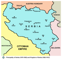
The 1878 borders correspond to present-day Central Serbia save for small parts in the south-west.
In the Balkan Wars (1912–13), Serbia further expanded its borders to the south, taking control of much of present-day Kosovo and North Macedonia.
Further territorial gains were made in the north (today's Vojvodina) and south-west (Sandžak region) in 1918, after World War I. Serbia became part of the new Kingdom of Serbs, Croats and Slovenes on December 1, 1918.