Blanca Peak
The fourteener is located 9.6 miles (15.5 km) north by east (bearing 9°) of the Town of Blanca, on the drainage divide separating Rio Grande National Forest and Alamosa County from the Sangre de Cristo Land Grant and Costilla County.
[b][1][2][6] The Blanca Peak Tripoint of Alamosa, Costilla, and Huerfano counties is located on the same drainage divide approximately 251 feet (77 m) northeast by north (bearing 30°) of the Blanca Peak summit at the boundary of the San Isabel National Forest.
Approximately 15 miles (24 km) to the north-northwest is Great Sand Dunes National Park and Preserve.
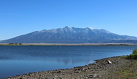
Blanca Peak is notable not only for its absolute height, but also for its great local relief and dominant position at the end of the range, rising high above the San Luis Valley to the west.
Three other fourteeners are nearby: Mount Lindsey to the east, Ellingwood Point to the north and Little Bear Peak to the southwest.
[9] The granite that makes up the Blanca massif is pre-Cambrian in age, dated at approximately 1.8 billion years old.
The major part of the Wet Mountains to the east and the Front Range to the northeast are also pre-Cambrian, also about 1.8 billion years old.