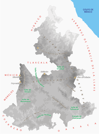
Sierra Norte de Puebla
Until the 19th century, the area was almost exclusively indigenous, with the four main groups still found here today, Totonacs, Nahuas, Otomis and Tepehuas, but coffee cultivation brought in mestizos (mixed indigenous/European people) and some European immigrants who took over political and economic power.
[1] Most of the Sierra Norte corresponds with the Puebla subregion of the Carso Huasteco, which covers an area of 448,927 hectares or thirteen percent of the state.
[5] The relative prosperity of the 20th century has spurred development of large towns with cement block structure, significantly heavier than traditional homes.
[4] Most of the surface water is in fast moving streams and small rivers, some of which run only in the rainy season and many of which can be torrential when rains are heavy.
[4] Other important rivers include the Pantepec, Laxaxalpan, San Pedro (Zun), Zempoala, Cedro Viego, Salteros and Martínez de la Torre.
The main aquifer is the Tecolutla, which has 70% of the underground fresh water in the area, followed by the Libres-Oriental, Martínez de la Torre-Nautla and Perote-Zayaleta.
It is economically and politically the most important area of the Sierra Norte and includes municipalities such as Huauchinango, Zacatlán, Chignahuapan, Tetela de Ocampo, Zacapoaxtla, Zaragoza and Teziutlán.
The coffee-growing region has elevations between 200 and 1,500 meters above sea levels with a very humid, temperate-warm climate, which is optimal for coffee and black pepper.
The Declive Austral (southern slope) de la Sierra is an arid area as the winds from the Gulf of Mexico that brings in moisture do not get this far as often.
Precipitation is lowest in winter because of wind patterns called “nortes.” These are polar air masses that collide with the warm waters of the Gulf as they move south.
[4] Temperate and humid – C(fm) is characterized by year round rain with an average annual temperature of less than 18 °C and precipitation varying from between 1,200 and 3,000.
One of the first organizations of this kind was the Cooperativa Agropecuaria Regional Tosepan Titataniske (CARTT) in the 1970s, with the aim of improving the prospects of small agricultural producers.
[10] The Comisión Nacional para el Desarrollo de los Pueblos Indígenas works in the areas with several centers in Huauchinango, Zacapoaxtla and Teziutlán as well as a radio station, XECTZ in Cuetzalan, called La Voz de la Sierra (The Voice of the Mountains) in Spanish and various indigenous languages.
Traditional men's dress consists of a shirt and pants of undyed cotton, with a wrap belt, a pouch bag, a palm hat, huaraches and a machete.
[11] The ceremony was named an Intangible Cultural Heritage by UNESCO in order to help the ritual survive and thrive in the modern world.
Due to the deforestation of much of the Sierra de Puebla and mountain areas of Veracruz, most voladores perform on permanent metal poles.
[20] Various other communities in the Sierra Norte regularly perform the Voladores dance or ritual including Chila Honey, Huauchinango and Tenango de Flores.
[1] The Sierra Norte de Puebla was once part of a larger indigenous region called Totonacapan, which extended from here east to the Gulf of Mexico coast in northern Veracruz.
[1][5] For the rest of the colonial period, the Sierra Norte would be almost completely populated by the same indigenous groups, Nahuas, Totonacs, Otomis and Tepehuas, living in the same overlapping territories for centuries.
The railway came to the Sierra Norte from Tulancingo, Hidalgo in the latter 19th century which allowed the shipping of tropical products such as coffee, sugar cane and fruit to Mexico City profitable.
However, the most important was headed by Mariano Olarte from 1836 to 1838 when the bishop of Puebla banned traditional Totonac Holy Week ceremonies because they were considered too pagan.
These moves were most successful in the Sierra Norte because the area generally favored the prevalent Liberal policies of the latter 19th century and the multicultural character of the region put the Totonacs under more pressure to assimilate.
This marginalization is most acutely found in the rural indigenous areas as power and wealth are concentrated in the major towns dominated by mestizos.
Other crops include potatoes, chili peppers, sugar cane, citrus fruit, bananas, plums, apples and peaches.
The main coffee-producing region for Puebla is the Sierra Norte which accounts for 91% of land planted with the crop and 97% of the total production with an average annual yield of 5.5 tons of coffee berries per hectare.
Chignahuapan is Mexico's largest producer of blown glass Christmas tree ornaments, with a production of 70 million per year among 400 workshops.
[1] In the 1970s, the Otomi of San Pablito, Pahuatlán began producing amate or bark paper commercially, a first almost exclusively for Nahua painters in the state of Guerrero.
The production has caused environmental damage as trees are stripped for bark and chemicals from the process such as caustic soda make their way into the San Pedro River.
Nature tourism for the region includes visiting rural towns, hiking, camping, environmental education, controlled hunting, photographic safaris and recreational fishing.
[1] The university began as the Instituto Poblano de Estudios Superiores in 1980 to serve students who cannot leave the area to pursue higher education.

near Zacatlán , Puebla.