Sierra de Guadarrama
Another interpretation considers unlikely that a minor river could design a vast mountain range, and makes the name derive from the Latin aquae dirrama, meaning 'water divide', which very aptly describes the position of the sierra between the two largest water basins in the Iberian Peninsula, those of the Douro, to the north, and of the Tagus, to the south.
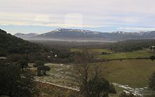
The Guadarramas form a natural division between the North and South mesetas of the Iberian Peninsula, part of the so-called Sistema Central.
In addition to the Cuerda Larga and La Mujer Muerta, a series of small mountains or foothills are located on the periphery of the main range.
For these reasons, the material making up the Sierra de Guadarrama is of more ancient origin than many other well-known mountain systems, such as the Pyrenees, the Alps, the Andes and the Himalayas.
In the mid Paleozoic era (between 360 and 290 mya), an initial substratum of ancient granites and sediments started bending and metamorphizing, forming gneiss.
Thereafter, approximately 290 and 250 mya during the Carboniferous period, the gneiss fractured, allowed a mass of magma to reach the surface which ultimately hardened into a granite shelf tableland.
In the final phase of the Paleozoic era, during the Permian period, the tectonic plate collision causing the whole mountain range to rise.
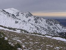
Finally, during the end of the Paleozoic through the Mesozoic era (between 250 and 65 mya) and up to the present, ongoing erosion processes reduced the size and smoothed and rounded the profile of the mountains of the Guadarramas.
This accounts for the presence of limestone (a sedimentary rock formed predominately from calcite derived from marine organisms) found in the rims of Guadaramma mountain peaks and in some of their interior caves.
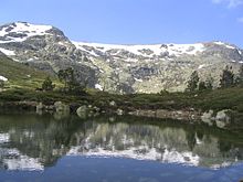
The action of glaciers during the Quaternary Period (1.8 mya up to the present) shaped several mountain profiles with small cirques, carved glacial lakes and left behind moraines.
Additionally, some traces of glacial passage are found in El Nevero and La Maliciosa in the form of sheepback-grooved rocks and small cirques.
Finally, in the last million years, the action of glaciers caused consolidation of the network of rivers crisscrossing the mountain slopes, carved valleys and terraces resulting in the current appearance of the landscape.
These towns are departure points for accessing the nearby mountain slopes and function as a centre of the tourism trade providing lodgings, restaurants and stores for visitors.
The climate of the Sierra de Guadarrama is marked by heavy precipitation which gives birth to the territory's numerous streams and rivers.
The flora and fauna of the Sierra de Guadarrama is very diverse, reflecting something of a synthesis between species common to the mediterranean landscape and climate of Spain's Central Plateau, and the more specialized plants and animals native to the higher altitude and mountainous terrain of the Pyrenees and Alps.
As it forms a natural barrier, the Guadarramas is crossed by important routes through the mountains linking the north and south of the Iberian Peninsula.
The routes date back to Roman times with the construction of their famous roads, one of which starts in the town of Cercedilla, crosses the mountains and terminates at the Fuenfría Pass.
The mountains are crossed by separate rail routes between Madrid and Ávila, Segovia and Burgos, connecting the capital to the north of the country.
For much of its history, the central part of the range – including the forests and grasslands on both sides of the mountains – was associated with the city of Segovia, at least as far back as its Roman control under the name of Segóbriga.
The legacy of that epoch can be seen in the splendid medieval walled cities occupying both sides of the mountains, such as Buitrago del Lozoya and Manzanares el Real in Madrid, and the Castillo de Pedraza in Segovia.
Likewise, in the Battle of Guadarrama during the Spanish Civil War (1936-1939) the range comprised an important front with skirmishes fought in the mountain passes between the loyalist and the rebel faction.
This culminated in the establishment of the Institución Libre de Enseñanza (Free Institution of Education) in 1876, which advocated an assimilation into Madrid's cultural values of the nearby mountain range's natural beauty.
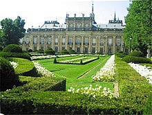
The magnificent scenery, the balmy summer climate and, especially, the proximity to Madrid and Segovia have resulted in the erection of many striking buildings and monuments on the hillsides of the Sierra de Guadarrama.
The complex has an enormous store of art, including masterworks by Titian, Tintoretto, El Greco, Velázquez, Rogier van der Weyden, Paolo Veronese, Alonso Cano, José de Ribera, Claudio Coello and others; its library containing thousands of priceless ancient manuscripts; and the complex has been designated a UNESCO World Heritage Site.
In the north face of Monte Abantos, surrounded by thick pine groves, is the Santa Cruz del Valle de los Caídos ("Holy Cross of the Valley of the Fallen").
The aim was to protect the range from degradation caused by the heavy human traffic as a result of its proximity to large cities such as Madrid.
[1] Formerly two high traffic areas of the Guadarrama mountains have achieved protected nature reserve status: Over the centuries, several myths and legends about the region have developed: