Signal du Petit Mont-Cenis
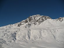
The Signal du Petit Mont-Cenis (in Italian Punta Clairy[2]) is a 3,162 m high mountain of the Cottian Alps.
It visually dominates the west side of the Mont Cenis lake and belongs to the main chain of the Alps, standing on the water divide between the watersheds of the Dora Riparia (Po Valley) and of the Arc (Rhone Valley).
[3] The mountain, although lying on the Alpine watershed between the Val di Susa and the Maurienne, is entirely in French territory following the boundary adjustments decided in the 1947 Treaty of Paris.
The area was interested by the Vallo Alpino and ligne Maginot fortifications and then saw heavy fights during the II World War, facing in 1945 the chasseurs alpins (French Army) and German mountain troops.
[4] The summit can be reached on foot starting from the refuge du Petit Mont Cenis with some scrambling, in about 3 hours' walk.