Sino-Indian War
[8][9] Amidst the Cuban Missile Crisis, China abandoned all attempts towards a peaceful resolution on 20 October 1962,[10] invading disputed territory along the 3,225-kilometre (2,004 mi) border in Ladakh and across the McMahon Line in the northeastern frontier.
The conflict ended when China unilaterally declared a ceasefire on 20 November 1962, and simultaneously announced its withdrawal to its pre-war position, the effective China–India border (also known as the Line of Actual Control).
[12][13] China and India shared a long border, sectioned into three stretches by Nepal, Sikkim (then an Indian protectorate), and Bhutan, which follows the Himalayas between Burma and what was then West Pakistan.
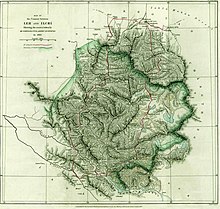
The western portion of the Sino-Indian boundary originated in 1834, with the conquest of Ladakh by the armies of Raja Gulab Singh (Dogra) under the suzerainty of the Sikh Empire.
[30][e] Following the Xinhai Revolution in 1911 which resulted in power shifts in China, the fall of Tzarist Russia in 1917 and the end of World War I in 1918, the British officially used the Johnson Line but had lost the urgency to enforce this boundary.
This treaty alarmed the Chinese which started displaying power by crushing rebellions and erecting flags and boundary stones in the Lohit Valley which were mostly removed by the British by 1910.
Due to the increased threat of Japanese and Chinese expansion during this period, British Indian troops secured the town as part of the defence of India's eastern border.
[51] To resolve any doubts about the Indian position, Prime Minister Jawaharlal Nehru declared in parliament that India regarded the McMahon Line as its official border.
[56] The Chairman of the Chinese Communist Party, Mao Zedong, was enraged and asked the Xinhua News Agency to produce reports on Indian expansionists operating in Tibet.
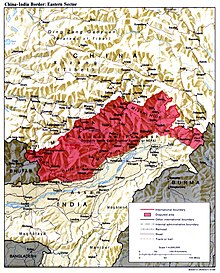
[58]: 131 As a consequence of their non-recognition of the McMahon Line, China's maps showed both the North East Frontier Area (NEFA) and Aksai Chin to be Chinese territory.
[citation needed] Given his foreknowledge of the coming Cuban Missile Crisis, Mao was able to persuade Khrushchev to reverse the Russian policy of backing India, at least temporarily.
Regarding Indian intentions, they began to act politically and to build a rationale based on the assumption that Nehru already had become a lackey of imperialism; for this reason he opposed border talks.
[83] Declassified CIA documents which were compiled at the time reveal that India's estimates of Chinese capabilities made them neglect their military in favour of economic growth.
All Indian troops within China's claimed territories in the eastern sector would be expelled, and the war would be ended with a unilateral Chinese ceasefire and withdrawal, followed by a return to the negotiating table.
[39] China also reportedly bought a significant amount of Indian rupee currency from Hong Kong, supposedly to distribute amongst its soldiers in preparation for the war.
[39] On 14 October, an editorial on People's Daily issued China's final warning to India: "So it seems that Mr. Nehru has made up his mind to attack the Chinese frontier guards on an even bigger scale. ...
History will pronounce its inexorable verdict ... At this critical moment ... we still want to appeal once more to Mr. Nehru: better rein in at the edge of the precipice and do not use the lives of Indian troops as stakes in your gamble.
Indian support for these outposts was not forthcoming, as evidenced by the Galwan post, which had been surrounded by enemy forces in August, but no attempt made to relieve the besieged garrison.
[citation needed] On 24 October, Indian forces fought hard to hold the Rezang La Ridge, in order to prevent a nearby airstrip from falling.
Beginning from 1 December 1962, the Chinese frontier guards will withdraw to positions 20 kilometres (12 miles) behind the line of actual control which existed between China and India on 7 November 1959.
In the middle and western sectors, the Chinese frontier guards will withdraw twenty kilometres (12 miles) from the line of actual control.Zhou had first given the ceasefire announcement to Indian chargé d'affaires on 19 November (before India's request for United States air support), but New Delhi did not receive it until 24 hours later.
In a May 1963 National Security Council meeting, contingency planning on the part of the United States in the event of another Chinese attack on India was discussed and nuclear options were considered.
[citation needed] During the conflict, Nehru wrote two letters on 19 November 1962 to U.S. President Kennedy, asking for 12 squadrons of fighter jets and a modern radar system.
The U.S. nonetheless provided non-combat assistance to Indian forces and planned to send the carrier USS Kitty Hawk to the Bay of Bengal to support India in case of an air war.
[104] As the Sino-Soviet split had already emerged, Moscow, while remaining formally neutral, made a major effort to render military assistance to India, especially with the sale of advanced MiG warplanes.
[111] The aftermath of the war saw sweeping changes in the Indian military to prepare it for similar conflicts in the future, and placed pressure on Nehru, who was seen as responsible for failing to anticipate the Chinese attack on India.
Arguably, the main lesson India learned from the war was the need to strengthen its own defences and a shift from Nehru's foreign policy with China based on his stated concept of "brotherhood".
[citation needed] Soon after the end of the war, the Indian government passed the Defence of India Act in December 1962,[119] permitting the "apprehension and detention in custody of any person [suspected] of being of hostile origin."
[124] Additionally, Ayub Khan was disappointed that Pakistan's decision not to take advantage of Indian vulnerabilities during its war with China was not rewarded with serious United States efforts in negotiations to settle the Kashmir dispute.
[142][143] In 1963, against the backdrop of the Sino-Indian War, Lata Mangeshkar sang the patriotic song "Aye Mere Watan Ke Logo" (literally, "Oh, the People of My Country") in the presence of Nehru.