Molenbeek-Saint-Jean
Located in the western part of the region, it is bordered by the City of Brussels, from which it is separated by the Brussels–Charleroi Canal, as well as by the municipalities of Anderlecht, Berchem-Sainte-Agathe, Dilbeek, Jette, and Koekelberg.
Experiencing a strong movement of immigration, mainly Moroccan, from the 1950s and 1960s, Molenbeek became increasingly multicultural with a minority Muslim population.
In France, the pronunciations [molənbɛk sɛ̃ ʒɑ̃] ("-beek" like "beck" in English) and [molənbɛkwa] (for molenbeekois) are often heard, but are rather rare in Belgium.
The dialectal forms Muilebeik and Meulebeik are still used by older adults of Belgian ancestry, whilst the abbreviations Molen and Molem are common among younger speakers.
The parish boundaries of St. John's Church were much greater than today, reaching as far as the river Senne,[19][20] and from the end of the 12th century, included a chapel dedicated to Saint Catherine.
On St. John's Day (24 June), a dancing procession took place, in which epileptics could be freed from their illness for a year if they crossed a bridge over the Molenbeek brook towards the church without their feet touching the ground.
[28] In addition, St. John's Church was dismantled in 1578 during the Calvinist Republic of Brussels, which lasted from 1577 to 1585, leading to further decline, though it was later rebuilt on the same spot.
The opening of the Brussels–Charleroi Canal in 1832 greatly increased the traffic of coal and thus the mechanisation of industry, which led to the development of foundries, engineering and metalworking companies in the municipality.
Remarkable new urban developments and garden cities such as the Cité Diongre were built at the beginning of the century to house the influx of newcomers.
Much of the original Belgian working-class population, when its financial means allowed it, left the lower Molenbeek for Brussels' newly developing suburbs.
[44][45] Where Molenbeek was once a centre of intense industrial activity, concentrated around the canal and the railway, most of those industries have disappeared to make way for large-scale urban renewal following the modernist Athens Charter, such as the Tour L'Écluse along the Boulevard Louis Mettewie/Louis Mettewielaan in the upper town and the Tour Brunfaut near the canal.
[46][47] In some areas of Molenbeek, the ensuing poverty left its mark on the urban landscape and scarred the social life of the community, leading to rising crime rates and pervading cultural intolerance.
In June 2011, the multinational company BBDO, citing over 150 attacks on their staff by locals, posted an open letter to then-mayor Philippe Moureaux, announcing its withdrawal from the municipality.
[50] According to Le Monde, the assassins who killed anti-Taliban commander Ahmed Shah Massoud both came from Molenbeek.
[52][53] The perpetrator of the Jewish Museum of Belgium shooting, Mehdi Nemmouche, lived in Molenbeek for a time.
[55] French police believe the weapons used in the Porte de Vincennes siege two days after the Charlie Hebdo shooting were sourced from Molenbeek.
[56] The bombers of the November 2015 Paris attacks were also traced to Molenbeek;[57] during the Molenbeek capture of Salah Abdeslam, an accomplice of the Paris bombers, protesters "threw stones and bottles at police and press during the arrest", stated the then-Interior Minister of Belgium, Jan Jambon.
[62][63][64] Ibrahim (born 9 October 1986 in Brussels) was involved in the attempted robbery of a currency exchange office in January 2010, where he shot at police with a Kalashnikov rifle.
Molenbeek, in common with the rest of Brussels, experiences an oceanic climate (Köppen: Cfb) with warm summers and cool winters.
The lower area, next to the canal, consists of working-class, predominantly migrant, communities, mostly of Moroccan (mainly Riffian and Berber) descent, with many being second- and third-generation.
[13] The territory of Molenbeek is very heterogeneous and is characterised by a mixture of larger districts including smaller residential and (formerly) industrial neighbourhoods.
It developed during the Industrial Revolution along the Brussels–Charleroi Canal and is currently in a fragile social and economic situation due to the decline of its economy and the poor quality of some of its housing.
They were designed by the architect and urban planner Louis Van der Swaelmen, and are named after King Albert I and his daughter, Princess Marie-José, the last Queen of Italy.
An old country road, today's Rue d'Osseghem/Ossegemstraat, which led to the Chaussée de Gand near the current Osseghem/Ossegem metro station, connected the hamlet to Molenbeek and Brussels.
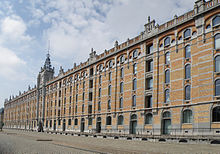
[76] Some of the main points of interest include: Moreover, several rundown industrial buildings have been renovated and converted into prime real estate and other community functions.
[88] The population has been described as "mainly Muslim" in the media;[90] however, actual figures are estimated to range between 25% and 40%, depending on the catchment area.
[7] Belgium does not collect statistics by religious beliefs, so exact figures are unknown, but the Muslim minority in the community is visibly significant.
[91] As of 2023[update], taking into account the nationality of birth of the parents, 69.16% of Molenbeek's population is of non-European origin (predominantly Moroccan and Syrian), 17.49% of European origin other than Belgian (mainly Romanian, Spanish, French, Italian, and Polish), while 13.31% is solely of native Belgian ancestry.
[103] The Boulevard Léopold II/Leopold II-laan in the north of Molenbeek is part of a monumental east–west axis, at the end of which is the National Basilica of the Sacred Heart in Koekelberg.
The former will also gain importance in the framework of the Brussels Regional Express Network (RER/GEN)'s development, which will connect the capital and surrounding towns.