Rogue River–Siskiyou National Forest
There are local ranger district offices located in Ashland, Butte Falls, Grants Pass, Jacksonville, and Prospect.
The former Siskiyou portion of the Rogue River–Siskiyou National Forest is located in parts of four counties in southwestern Oregon and northwestern California.
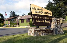
[1] There are local ranger district offices located in Cave Junction, Gold Beach, and Powers.
[6] On September 9, 1942, an airplane dropped bombs on Mount Emily in the Siskiyou National Forest, turned around, and flew back over the Pacific Ocean.
The national forest is home to some stands of old growth, including Port Orford cedar and Douglas fir in the Copper Salmon area.
The Rogue River–Siskiyou National Forest contains all or part of eight separate wilderness areas, which together add up to 565,900 acres (229,000 ha):[4]