Sonora
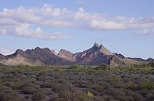
Sonora's natural geography is divided into three parts: the Sierra Madre Occidental in the east of the state; plains and rolling hills in the center; and the coast on the Gulf of California.
A third theory, written by Cristóbal de Cañas in 1730, states that the name comes from the word for a natural water well, sonot, which the Spaniards eventually modified to Sonora.
[21][27] The initial attraction of Sonora for the Spaniards was its fertile farmlands along the river valleys[28] and its position as part of a corridor linking the central Mexican highlands around Mexico City up the Pacific coast and on into Arizona and points north.
[28] By the end of the 19th century, however, the area received large numbers of immigrants from Europe, especially from Germany, Italy, and Russia, the Middle East, mainly Lebanon or Syria, and even China,[34] who brought new forms of agriculture, mining, livestock, industrial processes, ironwork, and textiles.
[21] The area's political vulnerability immediately after the war made it susceptible to buccaneers such as William Walker, Gaston de Raousset-Boulbon, and Henry Alexander Crabb, who attacked Sonoran ports such as Guaymas and Caborca.
[21] The economy did not begin to recover from the war until the late 1850s, when Ignacio Pesqueira became governor and attracted foreign investment to the state, especially in the mining sector, as well as worked to create markets abroad for agricultural products.
The governor of Coahuila, Venustiano Carranza, sought refuge in Sonora, and became one of the principal political leaders during the rest of the war, with his main base of operations in Hermosillo.
A number of the revolutionary leaders who joined Carranza in Sonora did not come from peasant backgrounds, but rather the lower middle class of hacienda-managers, shopkeepers, mill-workers, or schoolteachers, who opposed large-scale landowners and the Porfirian elite.
[65] According to Arizonan authorities, 2010 was a record year for deaths in Arizona for people crossing illegally from Sonora, with the bodies of 252 crossers found in the deserts between the New Mexico and California borders.
[37][71] The state's geography is divided into three regions created by the rise of the Sierra Madre Occidental mountains and the separation of the Baja California Peninsula, with all three running roughly north–south.
[70] As moist air masses move inland from the Pacific and the tropics and are forced against the mountains, they cool and this leads to precipitation, mostly rain but occasional snows in the highest regions.
While most of the rain falls in the mountainous areas, much of this water finds its way back to the western coastal plains in the form of rivers and streams that empty into the Gulf of California and fill underground aquifers.
After the las aguas, there may be additional moisture brought in by hurricanes, which generally move west along the Pacific coast of Mexico and occasionally come inland, especially in southern Sonora.
Dams, such as Alvaro Obregon, Adolfo Ruiz Cortines, Plutarco Elias Calles, Abelardo Rodriguez and Lázaro Cárdenas, have been built along some of these rivers, at least two of them where natural lakes existed.
While members of the Tohono O'odham have special border crossing privileges, these have become endangered as Mexican farmers encroach on tribal lands in Sonora, which are vulnerable to drug smugglers.
For centuries they have inhabited the central coast of the state, especially in Punta Chueca, El Desemboque and Kino Viejo as well as a number of islands in the Gulf of California in and around the Isla Tiburón.
[116][119] The Cocopah is the smallest native indigenous group to Sonora with about 170 members, who live mostly in San Luis Río Colorado, along the United States border, in addition to nearby communities in Arizona and Baja California.
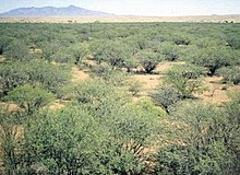
[130] There is some small-scale farming done in the state, especially in the highland areas, where farmers grow corn and other staples mostly for self-consumption; this unirrigated agriculture is highly dependent on the late-summer rainy season, as failure will result from the lack of rain.
After the Mexican Revolution, the federal government took control of Sonora's irrigation infrastructure and after World War II, began extensive dam and reservoir construction.
Leisure visitors from the United States tend to be between 40 and 65 years of age, married or in a relationship, educated at the university level or higher, with about thirty days of vacation time, and they primarily research travel options on the Internet.
[73] To enhance tourism in areas away from the primary beaches, the state of Sonora has set up several tourist routes for promotion as well as gained "Pueblo Mágico" status for one of its smaller cities.
Destinations include the towns Moctezuma, Villa Hidalgo, Huásabas, Granados, Huachinera, Bavispe, Nácori Chico, Fronteras, Nacozari and Cumpas, which have other attractions such as old haciendas, streams, forests and other forms of nature.
[145] The Ruta Sierra Mar ("Mountain Sea Route") is located in the south of the state among the towns around Álamos, Navojoa and Huatabampo, which contain a large number of colonial-era constructions.
[99] On each side of the border, there is a fifteen km strip, which is designated as a commercial trade zone, where both Mexicans and United States citizens can enter with limited visa requirements.
The main shopping street in Nogales is Avenida Obregón, which is crowded with pharmacies with lower prices than in the United States, stores selling knock offs of designer names such as Louis Vuitton, Cuban cigars, tequila, cheaper cigarettes and Mexican handcrafts, including some of the best work from artisans from Puebla, Guadalajara, Michoacán and Oaxaca.
Objects made from this wood are almost always decorative in nature in a wide variety of shapes such as sahuaro and other cacti, eagles, turtles, dolphins and other flora and fauna of the state, along with crosses.
In Arizpe and Álamos, they specialize in a type of chair made by bending and combining long flexible branches of willow and "guásima" (Guazuma ulmifolia) In the town of Tubutama, they make clocks of mesquite wood.
[155] Leather goods such as belts, shoes, jackets, wallets and more in made in locations such as Nácori Chico, Moctezuma, Pitiquito, Bacoachi, Banámichi, Huásbas, Arivechi and Ures.
[162] norteño music developed from the late 19th until the beginning of the 20th century, all along the borderlands of northern Mexico and the southwestern United States, with the influence of waltz, polkas, mazurkas and corridos.
They brought European staples of wheat, beef, dairy products, pork and more, as well as dishes and ingredients from the center and south of Mexico, such as tortillas, more varieties of chile peppers and tamales.