South Pass (Wyoming)
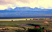
Though it approaches a mile and a half high, South Pass is the lowest point on the Continental Divide between the Central and Southern Rocky Mountains.
Because the Lewis and Clark Expedition of 1803-1806 was searching for a water route across the Continental Divide it did not learn of South Pass from local peoples.
Instead, the expedition followed a northerly route up the Missouri River, crossing the Rockies over difficult passes in the Bitterroot Range between present-day Montana and Idaho.
The first recorded crossing was made on October 22, 1812 by Robert Stuart, and six companions from the Pacific Fur Company of John Jacob Astor.
A Shoshone had told Stuart of "...a shorter trace to the South than that by which Mr. Hunt had traversed the R. Mountains..."[4][5] In 1856 Ramsay Crooks, one of the party, wrote a letter describing their journey: In 1811, the overland party of Mr. Astor's expedition, under the command of Mr. Wilson P. Hunt, of Trenton, New Jersey, although numbering sixty well armed men, found the Indians so very troublesome in the country of the Yellowstone River, that the party of seven persons who left Astoria toward the end of June, 1812, considering it dangerous to pass again by the route of 1811, turned toward the southeast as soon as they had crossed the main chain of the Rocky Mountains, and, after several days' journey, came through the celebrated 'South Pass' in the month of November, 1812.
The seven persons forming the party were Robert McClelland of Hagerstown, who, with the celebrated Captain Wells, was captain of spies under General Wayne in his famous Indian campaign, Joseph Miller of Baltimore, for several years an officer of the U.S. Army, Robert Stuart, a citizen of Detroit, Benjamin Jones, of Missouri, who acted as huntsman of the party, Francois LeClaire, a halfbreed, and André Valée, a Canadian voyageur, and Ramsay Crooks, who is the only survivor of this small band of adventurers.Stuart's "Travel Memorandum" was left with President James Madison, but the War of 1812 preempted western exploration.
Their caravan of 20 wagons, in place of the usual pack-train, supplied the fur trappers from Fort Bonneville, which they established near the Green River.
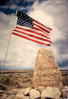
They were accompanied by the naturalist John Kirk Townsend, who documented this first use of the Oregon-California Trail, avoiding the Lander Cutoff used by the fur traders.
In 1836, Fitzpatrick guided the "First White Women to Cross This Pass", Narcissa Whitman and Eliza Hart Spalding, along with and their husbands, plus Miles Goodyear and William Gray.
[5]: 110, 113 [4]: 158 In 1842, John C. Fremont led a United States Army Corps of Topographical Engineers expedition to survey South Pass.
He wrote, "...it may be assumed to be about half-way between the Mississippi and the Pacific ocean, on the common traveling route...the emigrant road to Oregon.