Southern Black Forest
The Southern Black Forest (German: Südschwarzwald) is the highest part of the Black Forest, an area heavily transformed by ice age glaciation south of a line roughly from Freiburg im Breisgau to Donaueschingen.
Unlike the almost parallel mountain ridges and plateaux of the Northern Black Forest and the deeply incised central region, the Southern Black Forest is dominated by a central area of highland, from which most of the large valley emanate.
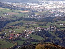
Flowing away from the Feldberg area are the Wiese heading southwest, the Alb southwards, the Schwarza/Schlücht which follows the terrain descending southeast, the Wutach, still called the Seebach and Gutach, initially heading east and the headstreams of the Dreisam dropping steeply northwestwards to the "Black Forest capital" of Freiburg im Breisgau.
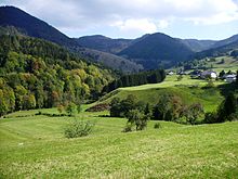
West of a line from the Höllental valley to the Wehra Gorge, the relief is characterised by rugged, steep-sided highlands with height differences of between 400 and 1000 metres; to the east is a land of rolling uplands with broad valleys and height differences of between 150 and 400 metres.
Unlike the Northern Black Forest, the Bunter sandstone cover with its plateau-like mountain shapes is thinner and has less influence on the relief.