Southern Serbia (geographical region)
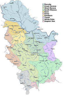
The region is characterized by the South Morava river, which flows almost entirely through Southern Serbia and which has historically connected the peoples who lived in its basin.
During the first half of the 20th century, the term was used to denote the area of Vardar Macedonia, Kosovo, Metohija and the Raška regions (so called Old Serbia).
In the period from 1919 to 1922, this area formed the province of Southern Serbia within the Kingdom of Serbs Croats and Slovenes.
Today, it consists of the following districts: Nišava, Jablanica, Toplica, Pirot and Pčinja.
The basin of South Morava occupies approximately the same territory as the region of commonly considered to be Southern Serbia.
In 364 AD, the imperial Villa Mediana 3 km (2 mi) was the site where emperors Valentinian and Valens met and divided the Roman Empire into halves which they would rule as co-emperors.
After the defeat of the Serbian forces, the Ottoman commander of Niš ordered the heads of the slain Serbs mounted on a tower to serve as a warning.
[9] After Serbia gained autonomy within the borders of the Belgrade pashaluk, the aspiration of Serbs from the south to join the motherland increased.
Most notable Governor of Niš Eyalet was Midhat Pasha, who later became Grand Vizier of Ottoman Empire.
The Austro-Hungarian telegram on the declaration of war on Serbia was received by Prime Minister Nikola Pašić in Niš on 28 July 1914.
Dimitrovgrad and Bosilegrad became part of newly founded Kingdom of Serbs, Croats and Slovenes according to the treaty of Neuilly-sur-Seine.
After the partition of Yugoslavia in World War II, municipalities of Vranje, Surdulica, Bosilegrad, Dimitrovgrad and Trgovište were annexed by Bulgaria, while the rest of the region became part of Serbia under the control of Government of National Salvation.
The Jablanički okrug region was the scene of fierce fighting between the occupying forces and the Yugoslav Partisans.
During communist rule in Socialist Federal Republic of Yugoslavia, Southern Serbia went through extensive industrialization.
After the end of Kosovo War, demilitarized buffer zone was established 5 km within the territory of Central Serbia.
It flows through Niš and suburb of Niška Banja, Bela Palanka, Pirot and Dimitrovgrad.
It differs from the standard Serbian language in that it has three grammatical cases instead of seven, as well as full retention of the aorist and the imperfect, loss of infinitive as in Bulgarian and Macedonian, frequent stress on the final syllable in polysyllabic words, etc.
Serbian authors Stevan Sremac and Borisav Stanković wrote several works in Torlakian dialect.
Today, Torlakian dialect is preserved in its original form in rural parts of Southern Serbia.
Financial and economical center of Southern Serbia is Niš with 4,678 Euros GDP per capita.
[21] In 2020 biggest exporters in Southern Serbia were Tigar Tyres from Pirot, Philip Morris International from Niš and Leoni AG from Prokuplje.