Pelham Bay Park
Part of New Netherland, it was destroyed in 1643 by a Siwanoy attack in reprisal for the unrelated massacres carried out under Willem Kieft's direction of the Dutch West India Company's New Amsterdam colony.
In 1654 an Englishman named Thomas Pell purchased 50,000 acres (20,000 ha) from the Siwanoy, land which would become known as Pelham Manor after Charles II's 1666 charter.
During the American Revolutionary War, the land was a buffer between British-held New York City and rebel-held Westchester, serving as the site of the Battle of Pell's Point, where Massachusetts militia hiding behind stone walls (still visible at one of the park's golf courses) stopped a British advance.
Before the colonization of what is now New York State in the 17th century, Pelham Bay Park comprised an archipelago of islands separated by salt marshes and peninsular beaches.
[7] The Siwanoy (transliterated as "southern people") were the first Native American tribe to inhabit the Long Island Sound's northern shoreline east to Connecticut.
[11] Two glacial erratics in the park, deposited during the end of the last ice age, were used ceremonially by the Siwanoy: the "Gray Mare" on Hunter Island, and Mishow near the Theodore Kazimiroff Nature Trail.
[17] The Siwanoy destroyed the Hutchinson settlement and killed the family in August 1643,[16]: 239 [18] in reprisal for the unrelated massacres carried out under Willem Kieft's direction of the Dutch West India Company's New Amsterdam colony.
[30]: 5 A brigade of 750 men under the command of the American Colonel John Glover were already inland, and they attacked the British advance units from behind a series of stone walls.
[32][33] In the 1870s, landscape architect Frederick Law Olmsted envisioned a greenbelt across the Bronx, consisting of parks and parkways that would align more with existing geography than a grid system similar to the Commissioners' Plan of 1811 in Manhattan.
[54] To alleviate the concerns of Westchester property owners who lost land during the park system's acquisition, the New York City Commissioners of Estimate distributed compensation payments.
[72] The current Orchard Beach recreational area and Split Rock golf course was created through the efforts of New York City park commissioner Robert Moses.
[84][85][86] The beach project involved filling in approximately 110 acres (45 ha) of LeRoy's and Pelham Bays with landfill,[3] followed by a total of 4,000,000 cubic yards (3,100,000 m3) of sand.
[103][104] Plans to expand the landfills in Pelham Bay Park in 1966, which would have created the City's second-largest refuse disposal site next to Fresh Kills in Staten Island, were met with widespread community opposition.
It suffered setbacks in August 1967 when the New York City Board of Estimate voted against an initial effort to create to protected area in the proposed landfill expansion site.
[117] NYPD officers on these cases theorized that the frequency of body dumpings might be attributable to two things: the park's remote location near highways, as well as a belief that the parkland is haunted by the remains of the Siwanoy buried there.
[124][125] Soon after, work started on a $2.9 million project to restore Pelham Bay Park's shoreline, which entailed renovating the seawall, adding a dog run, and creating a new walking trail.
It contains both golf courses, as well as the Thomas Pell Sanctuary; the Bartow-Pell Woods; Goose Creek Marsh; and the Siwanoy, Bridle, and Split Rock Trails.
The southern third of the peninsula is used as a firing range by the New York City Police Department (NYPD); the remaining wooded section is part of Pelham Bay Park.
[158] The New York City Department of Public Parks decided to create a "temporary" wooden bridge and remove the causeway to allow the bay's tides to flow freely.
[167] In their respective books, Henry B. Dawson (1886) and William Abbatt (1901) both wrote that Colonel John Glover reputedly stood on the rock and watched the British forces land during the battle.
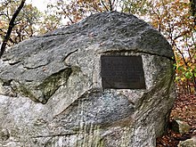
Split Rock (40°53′11″N 73°48′54″W / 40.88648°N 73.81492°W / 40.88648; -73.81492 (Split Rock)), a large dome-shaped granite boulder measuring approximately 25 feet (7.6 m) from north to south and 15 feet (4.6 m) from east to west, is located at the intersection of the New England Thruway and Hutchinson River Parkway, on a triangular parcel of land formed by these roads and a ramp that leads from the northbound Parkway to the northbound Thruway.
Banished from the Massachusetts Bay Colony in 1638[b] Because of her Devotion to Religious Liberty This Courageous Woman Sought Freedom from Persecution in New Netherland Near this Rock in 1643 She and her Household were Massacred by Indians This Tablet is placed here by the Colonial Dames of the State of New York ANNO DOMINI MCMXI Virtutes Majorum Filiae Conservant[180] The boulder is of enough historic importance that in the 1950s, Theodore Kazimiroff of the Bronx Historical Society convinced officials to move the planned Interstate 95 (New England Thruway) a few feet north to save Split Rock from being dynamited.
[194][195] It contains many glacial erratics, large boulders that were deposited during the last ice age,[194][193] as well as the largest continuous oak forest in Pelham Bay Park.
[2][135] North of the park is the village of Pelham Manor in Westchester County, and a 250-foot-wide (76 m) strip of land that is part of New York City due to a boundary error.
[92] The 1.1-mile-long (1.8 km), 115-acre (47 ha)[211] beach faces the Long Island Sound and is laid out in a crescent shape with a width of 200 feet (61 m) during high tide.
[83] The proposed course would be bounded by Pelham Manor to the north; the Harlem River and Port Chester Railroad (now Northeast Corridor) tracks to the west; and Shore Road to the southeast.
There was also a new two-story brick Greek Revival clubhouse adjacent to both of the 18-hole courses, with a golf store, Pro Shop, cafeteria, lockers, restrooms, and showers.
Citing the 1906 deed that transferred the bridge's maintenance to the company that owned the railroad below it, the city then filed a lawsuit to make Amtrak pay for the renovation.
Originating at City Island Road, it bears to the northeast before splitting into two spurs, one going east to the Rodman's Neck meadow and the other going north around Bartow Circle.
One spur goes northeast in a self-closing loop to the Bartow-Pell Mansion, and the other goes northwest to connect to Split Rock Trail before going around the Hutchinson River Parkway's interchange with Orchard Beach Road.