Steinkjer Municipality
Other populated areas in Steinkjer include the villages of Bartnes, Beitstad, Binde, Byafossen, Follafoss, Følling, Gaulstad, Henning, Hyllbrua, Kvam, Lerkehaug, Malm, Mære, Sela, Skei, Sparbu, Stod, Sunnan, Vassaunet, Vellamelen, and Verrastranda.
It started on 1 January 1902 when an unpopulated area from the neighboring Ogndal Municipality was taken for future growth of Steinkjer.
The official blazon is "Azure, a boat with raised square sail and topsail argent" (Norwegian: I blått en sølv båt med råseil og toppseil).
This means the arms have a blue field (background) and the charge is a Veranjekt (boat) with a raised square sail and topsail.
The boat has a tincture of argent which means it is commonly colored white, but if it is made out of metal, then silver is used.
The official blazon was "Azure, a mullet of six argent" (Norwegian: På blå bunn en sølv stjerne med seks odder).
The star had a tincture of argent which meant it was commonly colored white, but if it was made out of metal, then silver was used.
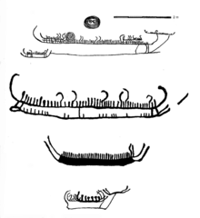
The Steinkjer area has been populated since the Stone Age, as shown by the Bølareinen rock carving, which depicts an almost life-sized reindeer and a bear.
Mære was a Norse religious place with sacrifices and seasonal gatherings (Norwegian: Hov) before Christianity came to Norway.
The second disaster happened on 21 and 22 April 1940, when the town was struck by Luftwaffe bombers during the Norwegian Campaign.
A few historical buildings – for example, the railway station and the town's college – survived the bombing.
The municipal council (Kommunestyre) of Steinkjer is made up of 39 representatives that are elected to four year terms.
Here is a list of people who have held this position:[38] Steinkjer Municipality is located at the head of Beitstadfjorden, the northern branch of the Trondheimsfjord system.
The easternmost point in Steinkjer Municipality lies just 13 kilometres (8.1 mi) from the border with Sweden.
Each year ferries from Hurtigruten make trips to the cruise port of Steinkjer, more than 130 kilometres (81 mi) of travel through the fjord system.
The landscape is dotted with wavy hills and dense spruce forests, as well as agricultural fields in the lowland areas.
Steinkjer is one of the northernmost areas with rich agriculture, allowing large production of grain.
Almost half of the inner town area consists of the large industrial park for wood products.
Most of the ship traffic is related to transportation of the vast forest resources present in Nord-Trøndelag such as timber and cellulose.
The climate of Steinkjer marks a border with the colder conditions typical of inland areas further north.
The surrounding woodlands and farmlands hold a host of the commoner Scandinavian species, some, like fieldfare and redwing, can be found in good numbers.
Steinkjer lies about 120 kilometres (75 mi) by road north of the city of Trondheim along the European route E6 highway.
Steinkjer is the home of the oldest network arch bridge in the world opened to traffic 1964.
Steinkjer houses the administration and Faculty of Society, Commerce, and Nature of Nord-Trøndelag University College.