Road map
Drawn around 1160 BC, it depicts routes along dry river beds through a mining region east of Thebes in Ancient Egypt.
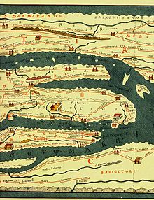
The Tabula Peutingeriana, a copy of a scroll originally dating to about 350 AD, plots the extent of the Cursus publicus, the Roman road network that ran from Europe and North Africa to West Asia.
[2] It is highly schematic, compressing the Mediterranean Sea to a sliver and orienting the Italian Peninsula to run east-west.
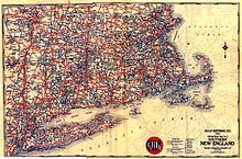
The book was the first collection of generalized road maps spanning Boston, New York, Baltimore, Washington and Philadelphia and was created by AAA Secretary Charles Howard Gillette.
AAA then established a Bureau of Touring Information in 1906, to supply members with all available data on roads, hotels, service facilities and motor vehicle laws.
These three companies produced most of the approximately eight billion free maps handed out at American filling stations over a period of about 1920 to 1980.
The Tabula Peutingeriana, mentioned above, is in effect an itinerarium in visual form, offering routes and distances with little geographical accuracy.
Electronic maps typically present a dynamically generated display of a region, with its scale, features, and level of detail specified by the user.
[11] Highway maps generally give an overview of major routes within a medium to large region ranging from a few dozen to a few thousand miles or kilometers.
Many old route maps are now considered collectible items and command increasing prices on auction sites and houses and on antique stores.