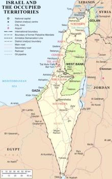
Borders of Israel
[1] Israel's two formally recognized and confirmed borders exist with Egypt and Jordan since the 1979 Egypt–Israel peace treaty and the 1994 Israel–Jordan peace treaty, while its borders with Syria (via the Israeli-occupied Golan Heights), Lebanon (via the Blue Line; see Shebaa Farms dispute) and the Palestinian territories (Israeli-occupied land largely recognized as part of the de jure State of Palestine) remain internationally defined as contested.
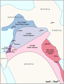
The Sykes–Picot Agreement of 1916 secretly divided the Ottoman Empire lands of Middle East between British and French spheres of influence.
The Mandate stated that Britain could 'postpone or withhold' application of the provisions dealing with the 'Jewish National Home' in the territory east of the Jordan River, then called Transjordan.
In September 1922, following Abdullah's probation period,[10] the British government presented a memorandum to the League of Nations defining the border of Transjordan and confirming its exclusion from all the provisions dealing with Jewish settlement.
[b] This would, according to professor of modern Jewish history Bernard Wasserstein, result in "the myth of Palestine's 'first partition' [which became] part of the concept of 'Greater Israel' and of the ideology of Jabotinsky's Revisionist movement".
[c][d] Palestinian-American academic Ibrahim Abu-Lughod, then chair of the Northwestern University political science department, suggested that the "Jordan as a Palestinian State" references made by Israeli spokespeople may reflect "the same [mis]understanding".
[20] For the latter, the agreement requires that the demarcation use a different presentation, and that it carry the following disclaimer: This line is the administrative boundary between Jordan and the territory which came under Israeli military government control in 1967.
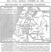
[22] The commission submitted its final report on February 3, 1922, and it was approved with some caveats by the British and French governments on March 7, 1923,[23] several months before Britain and France assumed their Mandatory responsibilities on September 29, 1923.
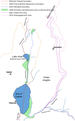
[24] In accordance with the same process, a nearby parcel of land that included the ancient site of Dan was transferred from Syria to Palestine early in 1924.
[23] The border was drawn so that both sides of the Jordan River and the whole of the Sea of Galilee, including a 10-metre-wide strip along the northeastern shore, were part of Palestine.
Following the 1948 Arab–Israeli War, Syria seized some land that had been allocated to the Jewish state and under the 1949 Armistice Agreements with Israel retained 66 square kilometers of that territory in the Jordan Valley that lay west of the 1923 Palestinian Mandate border (marked green on Map 4).
[29] Israel began building settlements throughout the Golan Heights, and offered the Druze and Circassian residents citizenship, which most turned down.
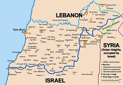
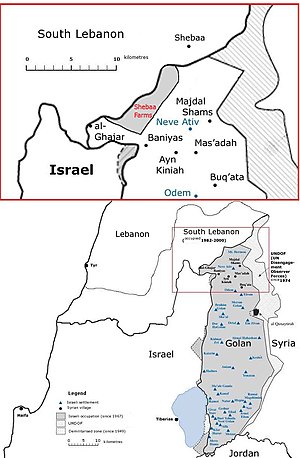
Israel's unilateral annexation has not been internationally recognized, and United Nations Security Council Resolution 242 refers to the area as Israeli-occupied.
During the 1990s, there were constant negotiations between Israel and Syria regarding a mediation of conflicts and an Israeli withdrawal from the Golan Heights but a peace treaty did not come to fruition.
[citation needed] The United Nations in June 2000 was called upon to decide the Lebanese border to determine whether Israel had fully withdrawn from Lebanon in compliance with UN Security Council Resolution 425.
At the same time, the United Nations did not have to consider the legality of the boundary between Lebanon and the Israeli-controlled Golan Heights, as that was not required for the purpose of Council Resolution 425.
The UN thus conducted its own survey based on the line for the purpose of Council Resolution 425, which called for "strict respect for the territorial integrity, sovereignty and political independence of Lebanon within its internationally recognized boundaries".
The United Nations cartographer and his team, assisted by UNIFIL, worked on the ground to identify a line to be adopted for the practical purposes of confirming the Israeli withdrawal.
While it was agreed that this would not be a formal border demarcation, the aim was to identify a line on the ground closely conforming to the internationally recognized boundaries of Lebanon, based on the best available cartographic and other documentary evidence.
On June 7, the completed map showing the withdrawal line was formally transmitted by the force commander of UNIFIL to his Lebanese and Israeli counterparts.
[citation needed] Between 1950 and 1967, Israeli and Lebanese surveyors managed to complete 25 non-contiguous kilometers and mark (but not sign) another quarter of the international border.
[citation needed] The Shebaa Farms conflict stems from Israel's occupation and annexation of the Golan Heights, with respect to that territory's border with Lebanon.
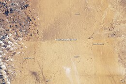
The British were also interested in making the border as short and patrollable as possible, and some contest that it did not take into account the needs of the local residents in the negotiations,[40] although its clauses did allow free access to the water sources west of the line to civilians, military and gendarmes from the Ottoman side, as well as full transhumance rights according to tribal rules for the Naqb (Negev) and Sinai Bedouin.
[41] It was defined as an "administrative separating line" for diplomatic reasons, allowing the Ottoman Empire to hold to its nominal sovereignty over Egypt.
[43] The Egypt–Israel peace treaty, signed on March 26, 1979, created an officially recognized international border along the 1906 line, with Egypt renouncing all claims to the Gaza Strip.
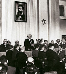
"[45] Epstein, Agent, Provisional Government of Israel said in a letter to President Truman seeking recognition from the U.S. government, sent immediately after the Declaration of May 14, 1948, "that the state of Israel has been proclaimed as an independent republic within frontiers approved by the General Assembly of the United Nations in its Resolution of November 29, 1947",[46] (i.e., within the area designated as the "Jewish state" in the partition plan).
The tide of battle soon turned against the Arabs, and Israel then launched a series of military offensives, greatly expanding its territorial holdings.
During the Six-Day War of 1967, Israel captured the West Bank from Jordan, Gaza Strip and Sinai peninsula from Egypt, and Golan Heights from Syria, and placed these territories under military occupation.
Israel has not made claims to any portion of Gazan territory and offered the entire area to Palestinians as part of the 2000 Camp David Summit.
[53] Secretary of State Rex Tillerson clarified "that the final status [for Jerusalem], including the borders, would be left to the two parties to negotiate and decide.