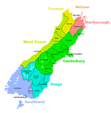
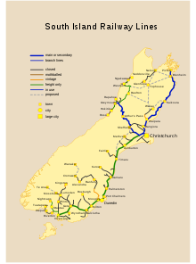
South Island
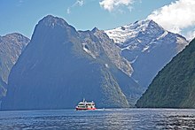
The east side of the island is home to the Canterbury Plains, while the West Coast is renowned for its rough coastlines, such as Fiordland, a very high proportion of native bush and national parks, and the Fox and Franz Josef Glaciers.
[19] Stretching from Kaikōura to North Otago, the drawings are estimated to be between 500 and 800 years old and portray animals, people and fantastic creatures, possibly stylised reptiles.
One notable feature of the Moriori culture, an emphasis on pacifism, proved disadvantageous when Māori warriors arrived in the 1830s aboard a chartered European ship.
Ngāti Māmoe then ceded the east coast regions north of the Waiau Toa / Clarence River to Kāi Tahu.
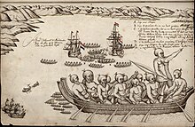
In November 1830, Te Rauparaha persuaded Captain John Stewart of the brig Elizabeth to carry him and his warriors in secret to Akaroa, whereby in subterfuge they captured the leading Kāi Tahu chief, Tama-i-hara-nui, and his wife and daughter.
[24] In 1836, the Ngāti Tama chief Te Pūoho led a 100-person war party, armed with muskets, down the West Coast and over the Haast Pass.
[25] Te Puoho took his captives over the Crown Range to Lake Wakatipu and thence to Southland, where he was killed, and his war party destroyed by the southern Ngāi Tahu leader Tūhawaiki.
The first Europeans known to reach the South Island were the crew of Dutch explorer Abel Tasman who arrived in his ships Heemskerck and Zeehaen.
It was subsequently Anglicised as New Zealand by British naval captain James Cook of HM Bark Endeavour who visited the islands more than 100 years after Tasman during (1769–70).
Also known as the Wairau Massacre in most older texts, it was the first serious clash of arms between the two parties after the signing of the Treaty of Waitangi and the only one to take place in the South Island.
Although the first Chinese migrants had been invited by the Otago Provincial government, they quickly became the target of hostility from white settlers and laws were enacted specifically to discourage them from coming to New Zealand.
Grey implemented the ordinance with such deliberation that neither Council met before advice was received that the United Kingdom Parliament had passed the New Zealand Constitution Act 1852.
The desire for the South Island to form a separate colony was one of the main factors in moving the capital of New Zealand from Auckland to Wellington that year.
This growing disparity has stabilised in recent years, with both the 2013 and 2018 censuses showing the South Island to have a very similar percentage of the national population (around 23%–24%).
Origin Energy has formed a joint venture with Anadarko Petroleum, the second-largest independent U.S. natural gas producer, to begin drilling for oil in the Canterbury Basin off the coast of Dunedin.
Today, the Deloitte South Island Index[50] is compiled quarterly from publicly available information provided by NZX, Unlisted and Bloomberg.
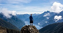
Popular tourist activities include sightseeing, adventure tourism, such as glacier climbing and Bungee jumping, tramping (hiking), kayaking, and camping.
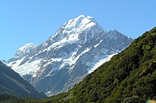
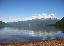
It is divided along its length by the Southern Alps, the highest peak of which is Aoraki / Mount Cook at 3,724 metres (12,218 ft), making it 9th-highest island, with the high Kaikōura Ranges to the northeast.
The east side of the island is home to the Canterbury Plains while the West Coast is renowned for its rough coastlines such as Fiordland, a very high proportion of native bush, and Fox and Franz Josef Glaciers.
The dramatic landscape of the South Island has made it a popular location for the production of several films, including The Lord of the Rings trilogy and The Chronicles of Narnia: The Lion, the Witch and the Wardrobe.
On 4 September 2010, the South Island was struck by a 7.1 magnitude earthquake, which caused extensive damage, several power outages, and many reports of aftershocks.
The Marlborough Sounds, a series of deep indentations in the coastline at the northern tip of the South Island, are in fact rias, drowned river valleys.
Advancing glaciers eroded large steep-sided valleys, and often carried piles of moraine (rocks and soil) that acted as natural dams.
The Canterbury Plains formed from the erosion of the Southern Alps (an extensive and high mountain range caused by the meeting of the Indo-Australian and Pacific tectonic plates) and from the alluvial fans created by large braided rivers.
A layer of loess, a rather unstable fine silt deposited by the foehn winds which bluster across the plains, covers the northern and western flanks of the peninsula.
The Otago Harbour was formed from the drowned remnants of a giant shield volcano, centred close to what is now the town of Port Chalmers.
Timaru was constructed on rolling hills created from the lava flows of the extinct Mount Horrible, which last erupted many thousands of years ago.
[69] The South Island has contributed to the Arts in New Zealand and internationally through highly regarded artists such as Nigel Brown, Frances Hodgkins, Colin McCahon, Shona McFarlane, Peter McIntyre Grahame Sydney and Geoff Williams.
The Tasman Police District covers 70,000 kilometres[clarification needed] of territory, encompassing the northern and most of the western portion of the South Island.
At cricket, the South Island is represented by the Canterbury Wizards, Central Stags, and Otago Volts in the Plunket Shield, one day domestic series, and the Super Smash.