Teplice District
Cities and towns are marked in bold and market towns in italics: Bílina - Bořislav - Bystřany - Bžany - Dubí - Duchcov - Háj u Duchcova - Hostomice - Hrob - Hrobčice - Jeníkov - Kladruby - Košťany - Kostomlaty pod Milešovkou - Krupka - Lahošť - Ledvice - Lukov - Měrunice - Mikulov - Modlany - Moldava - Novosedlice - Ohníč - Osek - Proboštov - Rtyně nad Bílinou - Srbice - Světec - Teplice - Újezdeček - Zabrušany - Žalany - Žim Teplice District borders Germany in the north.
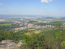
The terrain is very varied – hilly in the south, rather flat in the centre, and mountainous in the north.
The highest point of the district is the mountain Pramenáč in Košťany with an elevation of 910 m (2,990 ft), the lowest point is the river bed of the Bílina in Rtyně nad Bílinou at 160 m (520 ft).
[1] The most important river is the Bílina, which flows across the territory from west to east.
[3] České Středohoří is a protected landscape area that extends into the district.