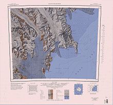
Terra Nova Bay
To the west of that cape is Oscar Point, facing Markham Island, and Shield Nunatak at the mouth of the Campbell Glacier, which extends its tongue southward into the bay.
[6][7] The climate in Terra Nova Bay is mostly dominated by the katabatic winds that blow off the David, Reeves and Priestly glaciers and Nansen Ice shelf.
Relative humidity is around 50% all year round, but due to the cold temperatures, the amount of water vapor is very low.
A small rock point along the north shore of Terra Nova Bay, 1 nautical mile (1.9 km; 1.2 mi) northwest of Markham Island.
A small but conspicuous island lying just off Oscar Point in the north part of Terra Nova Bay.
A prominent nunatak standing at the east side of the terminus of Campbell Glacier on the north shore of Terra Nova Bay.
This feature, a multiple volcanic cone, was so named by the New Zealand Geological Survey Antarctic Expedition (NZGSAE), 1965–66, because it looks like an old Viking shield.
An inlet 4 nautical miles (7.4 km; 4.6 mi) wide in the northwest corner of Terra Nova Bay, indenting the Northern Foothills just south of Mount Browning.
The name appears to have been applied by the BrNAE, 1901–04, and honors Belgian Antarctic explorer Lieutenant Adrien de Gerlache.
An island, 7 nautical miles (13 km; 8.1 mi) long, in Terra Nova Bay, lying close south of the Northern Foothills at the outer edge of the Nansen Ice Sheet.
[17] This article incorporates public domain material from websites or documents of the United States Geological Survey.