1979 Red River Valley tornado outbreak
On Tuesday, April 10, 1979, a widespread and destructive outbreak of severe weather impacted areas near the Red River between Oklahoma and Texas.
Thunderstorms developed over West and North Central Texas during the day within highly unstable atmospheric conditions following the northward surge of warm and moist air into the region, producing large hail, strong winds, and multiple tornadoes.
The F4 Vernon tornado struck southern and eastern parts of the city at approximately 4:45 p.m. CST, destroying several residential blocks and killing 11 people.
The severe weather event was widely observed by scientific instruments due to its serendipitous occurrence during a NASA field campaign.
[3] Although a cold front moving south during the day brought substantially cooler conditions to Oklahoma, it quickly weakened over Texas.
[5] The upper-tropospheric trough moved slower than modeling projected and by 6:00 a.m. CST April 10 had become oriented north-northeast to south-southwest, a characteristically negative tilt associated with many severe weather outbreaks.
[8] A wide expanse of stratus clouds covered much of Central Texas during the morning hours as a result of a stable airmass over the area.
[11] A line of thunderstorms developed over North Texas on the morning of April 10 in response to the surge of warm air, with small hail up to 1 in (25 mm) diameter associated with some of the storms.
[13] This surge of dry air, moving towards the east-northeast at roughly 30 kn (35 mph; 56 km/h), marked another potential region for storm development.
[11][8] Hail up to 1.5 in (38 mm) in diameter was reported in association with these storms, as well as a tornado east of Plainview at around 1:38 p.m. CST that caused no damage.
A third area of thunderstorms, albeit short-lived, developed west of Abilene, Texas, along the western edge of a small region of high pressure.
[14] A low-pressure area had also developed in the vicinity of Childress, Texas at around 1–2 p.m. CST, and would serve as a focusing mechanism for converging moisture over the Red River Valley.
[14][15] The National Severe Storms Forecasting Center (NSSFC) issued a tornado watch at 1:55 p.m. CST on April 10 for a 30,000 sq mi (78,000 km2) area encompassing parts of southwestern Oklahoma and north-central Texas.
[18] The arrival of the jet streak contributed to the conversion of the atmospheric instability accumulating near the Red River into thunderstorm formation.
In particular, three isolated supercell thunderstorms caused the majority of the severe weather during the afternoon and evening of April 10;[20][14] all developed in the localized area of supportive conditions near the frontal intersection.
[25] The arrival of a second and weaker region of strong winds within the nearby jet stream led to the development of severe thunderstorms, including some tornadoes, farther south over west-central and northern Texas during the overnight hours.
[17] The 27 tornadoes that were ultimately documented by the National Oceanic and Atmospheric Administration in Arkansas during April 1979 set a new monthly record high for the state.
[48] The Institute for Disaster Research conducted aerial surveys of the tornado, rating it an F4 on the Fujita scale based on the resulting damage.
[117] Of the fatalities, 25 were vehicle-related deaths; 11 people died while attempting to evade the tornado in their vehicles after fleeing their otherwise undamaged homes.
[61] The thunderstorm that eventually produced the Wichita Falls tornado formed north of Abilene and generally moved towards the northeast.
[14] At around 5:50 p.m. CST, a tornado developed in connection with the second mesocyclone on the southwestern flanks of the thunderstorm 3 mi (4.8 km) east-northeast of Holliday, Texas, in Archer County.
[48][50] The tornado darkened and widened to a width of roughly 0.5 mi (0.80 km) across as it moved into Wichita Falls at around 6:15 p.m. CST, impacting Memorial Stadium.
[48] As the tornado passed just south of the stadium, it rapidly strengthened to high-end F4 intensity and maintained this strength for the next 11 mi (18 km) of its path.
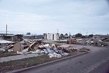
[48] The tornado widened to a width of about 1 mi (1.6 km) as it crossed Southwest Parkway into the Faith Village neighborhood, levelling several businesses and tossing vehicles about.
The tornado then crossed US 281 and moved into the Sun Valley neighborhood along the southern side of US 287, destroying apartments, houses, and businesses.
The Sunnyside Heights mobile home park north of the highway was destroyed, though no fatalities resulted as residents had evacuated.
[124] Homes were destroyed by the tornado south of TX-79 along a path from Wichita Falls to Dean, and Petrolia, contributing to the $15 million damage toll wrought by the twister in Clay County.
[125] The most extreme damage wrought by the tornado occurred at McNiel Junior High School and Southwest National Bank.
[61] The broader winds associated with the mesocyclone that spawned the Wichita Falls tornado caused light damage throughout much of the city.
[127][128] In 1984, the NWS produced a documentary covering the Wichita Falls tornado, titled Terrible Tuesday, in collaboration with the American Red Cross and FEMA.