Territorial era of Minnesota
Notably, the heavy Scandinavian immigration for which the state is known, and the pioneering days chronicled by author Laura Ingalls Wilder occurred after statehood in the later 19th century.
The Dakota Sioux, and later the Ojibwe, tribes hunted and gathered pelts trading with French, British, and later American traders at Grand Portage, Mendota, and other sites.
Their role in the fur trade gave them a steady stream of income and significant political influence even as the French, British, and Americans asserted territorial claims on the area.
[5][6] In the later 18th century trader Peter Pond explored the Minnesota River valley noting significant European settlement in the region in addition to the natives.
[14] Though the various parts of what is now Minnesota were claimed at different times by Spain, France, and Britain, none of these nations made significant efforts to establish major settlements in the area.
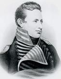
Lieutenant Zebulon Pike was sent by General Wilkinson, governor of the Louisiana Territory, to enforce U.S. sovereignty against British traders in the area and establish diplomatic and trading relationships with the native tribes.
[25][26] In 1817 Major Stephen H. Long of the U.S. Army Corps of Engineers led a waterborne expedition from Prairie du Chien to reach Saint Anthony Falls.
In 1823 Italian explorer Giacomo Constantino Beltrami who had split from the Long expedition in Pembina, found Lake Julia which he believed was the source of the Mississippi River.
[31][32] In 1835 George William Featherstonhaugh conducted a geological survey of the Minnesota River valley and wrote an account entitled A Canoe Voyage up the Minnay Sotor.
Lawrence Taliaferro, an agent of the U.S. Bureau of Indian Affairs who became an important figure in these mediations, spent 20 years at the fort, finally resigning in 1839.
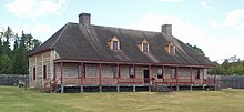
[46] In addition to these military bases, private companies operated numerous trading posts in the region that were often referred to as "forts", though they typically had little in the way of defensive fortifications.
[47] The two main Native American tribal groups that dominated Minnesota at the time the lands were acquired by the United States were the more established Dakota Sioux, and the Ojibwe who had migrated into the area more recently.
[22][52][53] Though Grand Portage was the only part of Minnesota that saw significant conflict during the war, natives throughout the region were recruited to fight further east in areas such as Green Bay.
In particular the half-Dakota British captain Joseph Renville heavily recruited among the Mdewakanton branch of the Dakota Sioux including chiefs Little Crow and Wapasha.
As a result of these conflicts numerous Métis migrated from the Red River area to central and eastern Minnesota, particularly in the vicinity of Saint Paul.
The U.S. government, though, failed to enforce the treaty agreements leading to Little Crow's pronouncement to Indian agent Taliaferro in 1829: "We made peace to please you, but if we are badly off we must blame you for causing us to give up so much of our lands to our enemies.
"[58] Following an 1846 treaty, the Winnebago tribes of Iowa were relocated to the Long Prairie reservation in central Minnesota in the late 1840s establishing an important presence in the territory.
[68] As well as Grand Portage, another significant fur shipping point in Minnesota was Fort Frances in the Rainy Lake region, near modern International Falls in the far north of the state.
[72] The Hudson's Bay Company continued to expand its presence north of the U.S. border establishing new posts such as Fort Alexander and Rat Portage.
[76][77] As this trade declined the lumber industry began to grow substantially in areas such as the Saint Croix Valley where valuable white pine was plentiful.
Nearby Mendota was established during the same period and, as the regional headquarters for the American Fur Company, also drew settlement in the area soon becoming Minnesota's commercial center.
Because of complaints from some residents at the fort, new restrictions were placed on the squatters forcing them to move down the Mississippi River, first to a site known as Fountain Cave, and then even further downriver.
John H. Stevens, an employee of Franklin Steele, pointed out that land on the west side of the falls would make a good site for future mills.
[106] As a result of heavy immigration from New England and New York—regions where most major towns had originated as trading centers rather than political or manufacturing centers—many new settlements in Minnesota were laid out so as to heavily favor the business districts rather than the city halls or courthouses.
Commenting on Minnesota's culture of the 1840s, Governor Alexander Ramsey described the streets of Saint Paul saying that it was common to see "the blankets and painted faces of Indians, and the red sashes and mocassins of French voyageurs and half-breeds, greatly predominating over the less picturesque costume of the Anglo-American race.
Warren was a good writer—his newspaper articles were eventually published as the only 19th century compendium of Ojibwe history and was elected to the territorial legislature before his death from consumption.
Author James Wesley Bond in 1853 described Minnesota before the 1850s as "a waste of woodland and prairie, uninhabited save by the different hordes of savage tribes from time immemorial.
French traders in the territories, and later even American army officers (including Josiah Snelling who commanded his namesake fort), continued to hold slaves with the blessings of many in Congress.
This decision helped to fuel rancor over slavery leading to the Bleeding Kansas conflicts, the Panic of 1857, and eventually the American Civil War.
[147] Joseph Rolette (also known as "Jolly Joe") was a fur trader and territorial legislator of partially Métis (mixed French/Native American) ancestry who became an iconic figure known in Minnesota history for his irreverence.
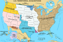


(1849–1858)