The Middle Road
The Middle Road was the name for a historic highway in the Canadian province of Ontario, which served to link the cities of Toronto and Hamilton.
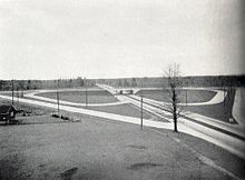
In 1934, the concept was reworked by Thomas McQuesten and Robert Melville Smith into a divided, limited access freeway, the first such intercity stretch in North America when it was opened in 1939.
[Note 1] The Middle Road provided the blueprint for Highway 401, an expressway that became a key contributor to the economic success of Ontario.
Most of the rows of trees along the old country lane were incorporated into the median, and new ones were planted in the gaps, as equal focus was given to functionality as aesthetics.
[8][Note 3] One of the elements of the Middle Road, to which engineers paid particular attention in future highway design, was controlled access.
A bowstring bridge, constructed in 1909, carried the Middle Road until 1932 and served as a farm lane until the section of the Queen Elizabeth Way into Toronto opened in 1940.
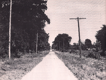
The Middle Road, a dirt lane named because of its position between the two, was not considered since Lake Shore and Dundas were both overcrowded and in need of serious repairs.
Smith, inspired by the German Autobahns – new "dual-lane divided highways," separated by a depressed grass centre crossing short distances between major cities – modified the design for Ontario roads,[27] and McQuesten ordered that the Middle Road be changed into this new form of highway.
It soon came time to name the new highway, and an upcoming visit by King George VI and Queen Elizabeth proved to be the focal point for a dedication ceremony.
On June 7, 1939, the two royal family members drove along the highway (which now connected to Niagara Falls) and passed through a light beam nearby the Henley Bridge in St. Catharines.
At the formal opening of the highway between Toronto and Niagara Falls on August 23, 1940, the entire length was declared The Queen Elizabeth Way by Thomas McQueston.