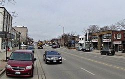
List of roads in Mississauga
This meant that the roads in the two surveys did not line up, except at 2+1⁄2 miles (4.0 km) intervals on either side of Hurontario (although due to the relatively short distance across the city and the presence of the deep Credit River valley in the south, only present Winston Churchill Boulevard and Dixie Road actually fit this pattern).
Lakeshore jogs 2 km south at Southdown Road in order to remain close to the shoreline, and it continues west into Oakville, before ending in Burlington.
Lakeshore is the only arterial road which crosses Hurontario Street but is not divided into east and west segments by it, instead being split by the Credit River.
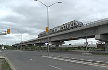
The Mississauga Transitway's Central Parkway Station is located on the road's east side, north of the intersection with Rathburn Rd and just south of where it passes underneath (but does not interchange with) Highway 403.
An unusual aspect of Burnhamthorpe is that, unlike other thoroughfares originating in Toronto, the road is relatively short in that city and its primary section runs through Mississauga.
It splits off the eastbound Mavis Road offramp and passes under it (westbound traffic uses Mavis itself to access the 403) then ducks beneath Confederation Parkway and runs parallel to the freeway until just west of Hurontario Street, where it turns south, crosses Rathburn Rd., and continues as City Centre Drive.
It resumes west of Tomken Road and ends in the cargo terminal area of Toronto Pearson International Airport.
[5] Due to an additional annexation west to Highway 407 in 2010,[6] the central section is now entirely within the city, but the road was never redesignated to reflect this.
However, the stretch between Dundas St. and the vicinity of the Highways 403 and 407 interchange still serves as the west city limits, and Ninth Line also continues entirely within Halton north and south of these points.
The Mississauga Transitway's Winston Churchill Station is located on the west side of the road, just north of where it interchanges with Highway 403.
Erin Mills Parkway is designated Regional Road 1,[7] and is a very busy six-lane arterial which begins at the Queen Elizabeth Way as a continuation of Southdown Rd.
on each side of Dundas St., and the second as a part of Turney Drive, which also incorporates a former section of Thomas Street) and runs north to the intersection of Mississauga and Turner Valley Roads.
The Mississauga Transitway's Erin Mills Station is located on the west side of the street, just north of where it interchanges with Highway 403.
The old portion was renamed, on each side of Highway 403, as Perivale and Rathkeale Roads, with their former status as Creditview being evident by the utility poles which still line them.
It originally ended at Eglinton, but was extended to its present length in two phases during the 1990s, bypassing Second Line West (see Terry Fox Way) to preserve Meadowvale Village, and then merging with it just north of the city limits in Brampton.
The Canadian Pacific Railway crossing north of Dundas St. (since replaced by an underpass) was the site of the infamous 1979 train derailment.
Confederation Parkway begins as a two-lane road at Queensway, widens to four lanes at Dundas St., and curves northwesterly towards Eglinton Ave.
EAST of Hurontario Kennedy Road runs north from Eglinton Ave. and continues south of it as Central Parkway.
The Mississauga Transitway's Tomken Station is located on the road's west side, just north of Eastgate Pkwy.
It is named after the Bramalea district of Brampton—Bramalea being a portmanteau of Brampton, Malton, and lea (an old English word meaning meadow or grassland) created by the farmer William Sheard, who owned a large parcel of cattle grazing land that he sold for the new venture—through which it passes after leaving Mississauga.
and was originally Fifth Line East, which once continued south to present-day Eglinton Avenue (passing through Elmbank en route), with the southern section being removed with the expansion of Pearson Airport.
Its original southern terminus was at Lower Baseline (present-day Eglinton Ave.) but today swings east to link with Dixon Road in Toronto at Highway 427.
Northwards, it runs through the Malton neighbourhood, and continues all the way to the Dufferin/Simcoe County line south of Stayner where it officially loses its name.
However, to the south, it curves eastwards to cross Highway 427 into Toronto, where it continues as one of that city's major east–west streets and eventually reaches Pickering.
and intersects with major arterial roads such as Mississauga Rd, Erin Mills Pkwy, and Winston Churchill Blvd.
The road originally ended at Unity Drive/Sladeview Crescent, but was later bridged over Highway 403 to reach Eglinton Ave. Ridgeway was proposed to be the western terminus of the Mississauga Transitway, but the busway was only constructed as far west as Winston Churchill Blvd.
On October 19, 2021, the replacement bridge was struck by a dump truck with the box tilted up, causing minor damage to the structure.
Indian Line is a short industrial side street running north from Campus Road, fronting Highway 427.
Sherway Drive is a residential street in the southeast area of the city, running east off Dixie Rd to the Etobicoke Creek.
Morning Star Drive is a minor crosstown street running from Airport Road to Humberwood Boulevard, in Toronto.