Thermal Emission Imaging System
Additionally, it helps scientists to understand how the mineralogy of Mars relates to its landforms, and it can be used to search for thermal hotspots in the Martian subsurface.
THEMIS is managed from the Mars Space Flight Facility at Arizona State University and was built by the Santa Barbara Remote Sensing division of Raytheon Technologies Corporation, an American multinational conglomerate headquartered in Waltham, Massachusetts.
Eight of these have wavelengths between 6 and 13 micrometers, an ideal region of the infrared spectrum to determine thermal energy patterns characteristic of silicate minerals.
In a THEMIS image taken at night, however, thermophysical properties of the surface can be inferred, such as temperature differences due to the materials' grain size (thermal inertia).
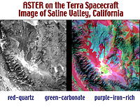
The presence of minerals such as carbonates, silicates, hydroxides, sulfates, amorphous silica, oxides, and phosphates can be determined from THEMIS measurements.
The THEMIS infrared camera was designed to be used in conjunction with data from the Thermal Emission Spectrometer (TES), a similar instrument on Mars Global Surveyor.
The instrument's approach provides data on localized deposits associated with volcanoes, hydrothermal processes, and the alteration of minerals by surface and/or subsurface water.


