Tigray Region
Some modern historians, including Stuart Munro-Hay, Rodolfo Fattovich, Ayele Bekerie, Cain Felder, and Ephraim Isaac consider this civilization to be indigenous, although Sabaean-influenced due to the latter's dominance of the Red Sea.
Others, including Joseph Michels, Henri de Contenson, Tekletsadik Mekuria, and Stanley Burstein, have viewed Dʿmt as the result of a mixture of Sabaean and indigenous peoples.
By the reign of Endubis in the late 3rd century, Aksum had begun minting its own currency and was named by Mani as one of the four great powers of his time, along with China and the Sassanid and Roman empires.
[24][25] In the 11th century the Tigrinya-speaking lands (Tigray-Mareb Melash) were divided into two provinces, separated by the Mereb River, by the newly enthroned Agaw emperors.
He also stated that Tigray-Mereb Melash was divided into 24 smaller political units (principalities), twelve of which were located south of the Mereb and governed by the Tigray Mekonen, based in Enderta.
[27] The Book of Aksum, written and compiled mainly in the period from the sixteenth to seventeenth centuries, shows a traditional schematic map of Tigray with the city of Aksum at its center, surrounded by the 13 principal provinces: "Tembien, Shire, Serae, Hamasien, Bur, Sam'a, Agame, Amba Senayt, Garalta, Enderta, Sahart and Abergele.
Rulers of Tigray such as Ras Wolde Selassie alternated with others, chiefly those of Begemder or Yejju, as warlords to maintain the Ethiopian monarchy during the Zemene Mesafint.
Although the first Woyane rebellion of 1943 had shortcomings as a prototype revolution, historians agree that it involved a fairly high level of spontaneity and peasant initiative.
Following the outbreak of the Ethiopian Revolution in February 1974, the first signal of any mass uprising was the actions of the soldiers of the 4th Brigade of the 4th Army Division in Nagelle in southern Ethiopia.
In July 1974, the Derg obtained key concessions from the emperor, Haile Selassie, which included the power to arrest not only military officers but government officials at every level.
Soon both former Prime Ministers Tsehafi Taezaz Aklilu Habte-Wold and Endalkachew Makonnen, along with most of their cabinets, most regional governors, many senior military officers and officials of the Imperial court were imprisoned.
In October 1978, the Derg announced the National Revolutionary Development Campaign to mobilize human and material resources to transform the economy, which led to a Ten-Year Plan (1984/85–1993/94) to expand agricultural and industrial output, forecasting a 6.5% growth in GDP and a 3.6% rise in per capita income.
Hundreds of thousands fled economic misery, conscription, and political repression, and went to live in neighboring countries and all over the Western world, creating an Ethiopian diaspora.
Toward the end of January 1991, a coalition of rebel forces, the Ethiopian People's Revolutionary Democratic Front (EPRDF) captured Gondar, the ancient capital city, Bahar Dar, and Dessie.
[citation needed] John Young, who visited the area several times in the early 1990s, attributes this delay in part to "central budget restraint, structural readjustment, and lack of awareness by government bureaucrats in Addis Ababa of conditions in the province", but notes "an equally significant obstacle was posed by an entrenched, and largely Oromo and Southern-dominated, central bureaucracy which used its power to block government-authorized funds from reaching Tigray".
[30] At the same time, a growing urban middle class of traders, businessmen and government officials emerged that was suspicious of and distant from the victorious EPRDF.
A 2002 United Nations decision awarded much of this land to Eritrea, but Ethiopia did not accept the ruling until 2018, when a bilateral agreement ended the border conflict.
As smaller towns had been growing, they had started providing a larger range of services, such as markets and even banks, that encouraged locals to travel there rather than to their formal woreda centre.
In 2018 and 2019, after multiple village discussions that were often vigorous in the more remote areas, 21 independent urban administrations were added and other boundaries re-drawn, resulting in an increase from 35 to 88 woredas in January 2020.
The East African Orogeny led to the growth of a mountain chain in the Precambrian (up to 800 Ma [million years ago]), which was largely eroded afterwards.
[34][35][36] Around 600 Ma, the Gondwana break-up led to the presence of tectonic structures and a Palaeozoic planation surface, that extents to the north and west of the Dogu'a Tembien massif.
The break-up of Gondwana (Late Palaeozoic to Early Triassic) led to an extensional tectonic phase, what caused the lowering of large parts of the Horn of Africa.
At the beginning of the Caenozoic, there was a relative tectonic quiescence, during which the Amba Aradam Sandstones were partially eroded, which led to the formation of a new planation surface.
[42] A new magma intrusion occurred in the Early Miocene, which gave rise to phonolite plugs, mainly in the Adwa area and also in Dogu'a Tembien.
Besides elephants in Western Tigray and the endemic gelada baboon on the highest mountains, large mammals in the region, with scientific (italics), English and Tigrinya language names, are:[50] The most common pest rodents with widespread distribution in agricultural fields and storage areas are three Ethiopian endemic species: the Dembea grass rat (Arvicanthis dembeensis, sometimes considered a subspecies of Arvicanthis niloticus), Ethiopian white-footed rat (Stenocephalemys albipes), and Awash multimammate mouse (Mastomys awashensis).
Consequently, Tigray achieved a fair amount of rainfall during the rainy season, from August to September, but quickly lost these waters downstream.
The dams needed to create these basins are typically an embankment of a few hundreds of meters, closing off one part of a valley, with a maximum height of 20 metres.
Besides effects on biodiversity,[53][75][76] water infiltration, protection from flooding, sediment deposition,[77] carbon sequestration,[78] people commonly have economic benefits from these exclosures through grass harvesting, beekeeping and other non-timber forest products.
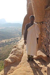
Similar in design to those of Lalibela in the Amhara Region, these churches are found in four or five clusters – Gheralta, Teka-Tesfay, Atsbi and Tembien – with Wukro sometimes included.
Looting has become a major issue in the Tigray Region, as archaeological sites have become sources for construction materials and ancient artifacts used for everyday purposes by local populations.