This Timeline of European imperialism covers episodes of imperialism outside of Europe by western nations since 1400; for other countries, see Imperialism § Imperialism by country.
World map at the
Padrão dos Descobrimentos
, Lisbon, with early Portuguese exploration and imperial projects.
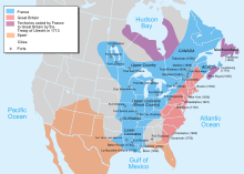
Map of territorial claims in
North America
by 1750, before the
French and Indian War
, which was part of the greater worldwide conflict known as the
Seven Years' War
(1756 to 1763). Possessions of Britain (pink), France (blue), and Spain. (White boarder lines mark later Canadian Provinces and US States for reference)
Map of the northern part and parts of the southern parts of the America, from the mouth of the Saint Laurent River to the Island of Cayenne, with the new discoveries of the Mississippi (or Colbert) River. This map shows the results of the expeditions of Father Marquette and L. Jolliet (1673) and the Cavelier de la Salle expedition in the Mississippi valley. The map shows three forts built between 1679 and 1680: Conty fort (near Niagara Falls), Miamis Fort (south of Michigan lake), and Crèvecœur fort (Left bank of the Illinois River). Mississippi river course is only shown upstream of Ohio confluence.
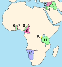
Central and east Africa, 1898, during the Fashoda Incident.