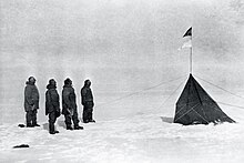
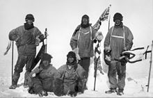
Timeline of European exploration

This timeline of European exploration lists major geographic discoveries and other firsts credited to or involving Europeans during the Age of Discovery and the following centuries, between the years AD 1418 and 1957.

Despite several significant transoceanic and transcontinental explorations by European civilizations in the preceding centuries, the precise geography of the Earth outside of Europe was largely unknown to Europeans before the 15th century, when technological advances (especially in sea travel) as well as the rise of colonialism, mercantilism, and a host of other social, cultural, and economic changes made it possible to organize large-scale exploratory expeditions to uncharted parts of the globe.

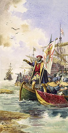
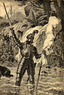
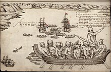
The Age of Discovery arguably began in the early 15th century with the rounding of the feared Cape Bojador and Portuguese exploration of the west coast of Africa, while in the last decade of the century the Spanish sent expeditions far across the Atlantic, where the Americas would eventually be reached, and the Portuguese found a sea route to India.

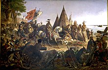
In the 16th century, various European states funded expeditions to the interior of both North and South America, as well as to their respective west and east coasts, north to California and Labrador and south to Chile and Tierra del Fuego.

In the 17th century, Russian explorers conquered Siberia in search of sables, while the Dutch contributed greatly to the charting of Australia.

Columbus before the Queen , imagined by Emanuel Gottlieb Leutze , 1843
Vasco da Gama lands at Calicut , illustration for Os Lusíadas, 1880 by Ernesto Casanova
An old painting depicting a wooden sailing ship with sails full blown by the wind
Pedro Álvares Cabral 's ship on the fleet that sighted the Brazilian mainland for the first time on 22 April 1500. From the manuscript Memória das Armadas que de Portugal passaram à Índia
Vasco Núñez de Balboa claiming possession of the Mar del Sur ("South Sea").
Map of the island city Tenochtitlán and Mexico gulf made by one of Hernán Cortés ' men, 1524, Newberry Library , Chicago
Discovery of the Mississippi by William H. Powell (1823–1879) is a Romantic depiction of de Soto seeing the Mississippi River for the first time. It hangs in the United States Capitol rotunda .
Francisco Vásquez de Coronado Sets Out to the North , by Frederic Remington , 1861–1909
Cabrillo National Monument in San Diego, California
Crew of Willem Barentsz fighting a polar bear , 1596
A 17th-century koch in a museum in Krasnoyarsk . Kochi were used to explore the Siberian watershed and coasts by men such as Kurochkin, Perfilyev and Dezhnev.
"Murderers' Bay", on the South Island of New Zealand, where several of Tasman's men were killed by Maori in December 1642.
The expedition of Semyon Dezhnyov by Klavdy Lebedev
Pere Marquette and the Indians at the Mississippi River, oil painting (1869) by Wilhelm Lamprecht (1838–1906), at Marquette University .
James Cook 's map of New Zealand
"Mount Rainier from the south Part of Admiralty Inlet". The mountain was discovered by Vancouver during his exploration of Puget Sound in the spring of 1792.
Inscription at the end of the Alexander Mackenzie's Canada crossing located at 52°22′43″N 127°28′14″W  /  52.37861°N 127.47056°W  / 52.37861; -127.47056
The famous map of Lewis and Clark's expedition. It changed mapping of northwest America by providing the first accurate depiction of the relationship of the sources of the Columbia and Missouri rivers, and the Rocky Mountains.
Colour drawing of Simon Fraser's 1808 descent of the Fraser River.
"The Crews of H.M.S. Hecla & Griper Cutting into Winter Harbour, 26 September 1819". An engraving from the journal published in 1821.
John Franklin's party encamped at Point Turnagain, the furthest point he reached.
HMS Investigator , on the northwestern coast of Banks Island, 20 August 1851.
Map drawn by Robert McClure detailing the Northwest Passage, including the 1851 route of the Investigator .
The first ascent of the Matterhorn, by Gustave Doré .
The original survey map created by L.M. D'Albertis in 1876.
A group of men pose on the ice with dogs and sledges, with the ship's outline visible in the background
Nansen and Johansen finally depart on their polar journey, 14 March 1895. Nansen is the tall figure, second from left; Johansen is standing second from right.
The Mekong Exploration Commission at Angkor in 1866
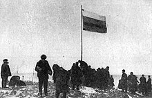
From left to right: Francis Garnier , Louis Delaporte , Clovis Thorel, Captain Ernest Doudart de Lagrée , Lucien Joubert, Louis de Carné
engraving from photo by Émile Gsell
Amundsen's party at the South Pole, December 1911. From left to right: Amundsen , Hanssen , Hassel and Wisting (photo by fifth member Bjaaland) .
Five men in heavy clothing and headgear; three are standing and two seated on the ground. The standing men carry flags; all five have dejected expressions
Scott's party at the South Pole, 18 January 1912. L to R: (standing) Wilson , Scott , Oates ; (seated) Bowers , Edgar Evans .
Severnaya Zemlya – raising of the Russian flag in 1913.