Timeline of the 1990–91 South Pacific cyclone season
TCWC Nadi and TCWC Wellington both use the Australian Tropical Cyclone Intensity Scale, and measure windspeeds over ten minutes, while the JTWC and the NWOC measured sustained winds over one minute and use the Saffir–Simpson Hurricane Scale.
It documents tropical cyclone formations, strengthenings, weakenings, landfalls, extratropical transitions, and dissipations during the season.
[2] As a result, only three tropical cyclones occurred within the South Pacific basin between 160°E and 120°W, which made the season one of the least active on record.
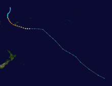
[4] After peaking as a category three severe tropical cyclone on the Australian tropical cyclone intensity scale, Sina affected Fiji, Tonga, Niue and the Southern Cook Islands with total damage estimated at over 18.5 million before it was last noted on December 4, as it was absorbed by an advancing trough of low pressure near 50°S.
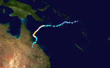
[8] The final tropical cyclone of the season, Lisa, moved into the Southern Pacific on May 11 at its peak intensity of 110 km/h (75 mph).
[2][5] During the next day as the storm moved towards the subtropical jet, Lisa rapidly weakened into a tropical depression before passing over Anatom Island without causing any significant damage.