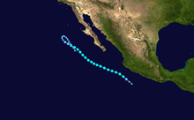
Timeline of the 2012 Pacific hurricane season

The 2012 Pacific hurricane season was an above-average year in which seventeen named storms formed.

These dates conventionally delimit the period during each year when most tropical cyclones form in the northeastern Pacific Ocean.

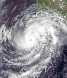
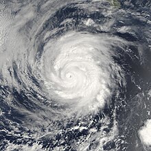
In late May, Hurricane Bud paralleled the western Mexico coastline before dissipating, causing minor damage and but no reported fatalities.

[5] This timeline includes information that was not released in real time, meaning that data from post-storm reviews by the National Hurricane Center, such as a storm that was not operationally warned upon, has been included.

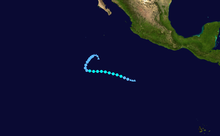
This timeline documents tropical cyclone formations, strengthening, weakening, landfalls, extratropical transitions, and dissipations during the season.

An image depicting the track of a short-lived and weak tropical storm.
Storm path of Tropical Storm Aletta
A visible satellite image of an intensifying Category 2 hurricane with a clear eye.
Hurricane Bud prior to peak intensity on May 24
A visible satellite image of a small and compact hurricane nearing the southern coastline of Mexico.
Hurricane Carlotta nearing Mexico on June 15
A visible satellite image of a well-defined hurricane with spiral banding and a clear eye.
Hurricane Daniel as a Category 1 hurricane on July 7
An image of the track of a long-lived and potent Pacific hurricane.
Storm Path of Hurricane Emilia
A visible satellite image of an intensifying Category 2 hurricane out at sea.
Hurricane Fabio near peak intensity on July 14
A visible satellite image of a small hurricane in the open Pacific.
Hurricane Gilma near peak intensity on August 8
A visible satellite image of a well-organized hurricane with a large eye.
Hurricane Ileana at peak intensity on August 30
An image of the track of a weak tropical storm in East Pacific.
Storm path of Tropical Storm Kristy
A visible satellite image of a Category 1 hurricane on September 17.
Hurricane Lane near peak intensity on September 17
A visible satellite image of a major hurricane in the East Pacific.
Hurricane Miriam shortly after peak strength on September 24
An image of the track of a short-lived and erratic tropical storm.
Storm path of Tropical Storm Olivia
A visible satellite image of a well-defined hurricane with a clear eye and spiral banding.
Paul as a major hurricane on October 15