Hurricane Bud (2012)
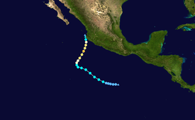
The wave slowly intensified as it moved towards the west as an area of thunderstorms, producing showers of the Windward Islands.
[4] After wind shear caused it to become less organized later that day,[5] the system began showing signs of development starting on May 19.
[7] Later that day, the National Hurricane Center noted that "conditions appear favorable for a tropical depression to form tonight or Monday.
"[8] It is estimated that Tropical Depression Two-E developed at 1800 UTC on May 20, while located about 525 miles (845 km) south of Acapulco, Guerrero.
Bud remained at this intensity for one day before strengthening, starting early on May 23, and reached winds of 65 mph (105 km/h) during the afternoon.
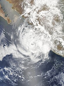
Late on May 24, Bud intensified further into a Category 3 Major Hurricane, and obtained a peak intensity of 115 mph winds (185 km/h), with a minimum central low pressure of 960 mbars.
[10] Hurricane Bud was able to maintain Category 3 intensity for the next several hours, even when its outer rainbands began moving onshore in Western Mexico.
During the mid-afternoon of May 25, Bud weakened down to a strong tropical storm, as it began making landfall on Western Mexico.
[12] By early on May 24, the Government of Mexico issued a tropical storm watch from Punta San Telmo to La Fortuna.
[18][19] Prior to Bud's rapid dissipation offshore, the storm produced heavy rainfall and waves of 6 feet (1.8 m) in Melaque, a town in western Jalisco.
Tropical storm (39–73 mph, 63–118 km/h)
Category 1 (74–95 mph, 119–153 km/h)
Category 2 (96–110 mph, 154–177 km/h)
Category 3 (111–129 mph, 178–208 km/h)
Category 4 (130–156 mph, 209–251 km/h)
Category 5 (≥157 mph, ≥252 km/h)
Unknown