Timeline of the 2016 Atlantic hurricane season

[3][4] The season officially began on June 1 and concluded on November 30, dates which conventionally delimit the period during each year when a majority of tropical cyclones form in the Atlantic Ocean.

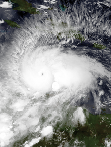
[10] In late September and early October, Hurricane Matthew wrought destruction throughout the Caribbean Sea and Southeastern United States, resulting in $15.09 billion (2016 USD) in damage and 603 deaths.

[12] Following the 2016 season, the names Matthew and Otto were retired from reuse in the North Atlantic by the World Meteorological Organization.

[13] This timeline documents tropical cyclone formations, strengthening, weakening, landfalls, extratropical transitions, and dissipations during the season.

Additionally, figures for maximum sustained winds and position estimates are rounded to the nearest 5 units (knots, miles, or kilometers), following the convention used in the National Hurricane Center's products.

Satellite image of a well-defined hurricane near the Azores on January 14
Hurricane Alex at peak intensity on January 14
A disorganized Tropical Storm Bonnie positioned southeast of South Carolina on May 28
Tropical Storm Bonnie at its initial peak intensity on May 28
A track map of Tropical Storm Colin in early June
Storm path of Tropical Storm Colin during early June
A track map of Tropical Storm Danielle during late June
Storm path of Tropical Storm Danielle during late June
Visible satellite imagery of an intensifying Hurricane Earl approaching Belize on August 3
Hurricane Earl approaching Belize on August 3
A track map of Tropical Storm Fiona during mid-August
Storm path of Tropical Storm Fiona during mid-August
Visible satellite imagery of Hurricane Gaston nearing major hurricane intensity on August 28
Hurricane Gaston on the cusp of major hurricane intensity on August 28
Visible satellite imagery of Hurricane Hermine approaching Florida on September 1
Hurricane Hermine approaching the coastline of Florida on September 1
A visible satellite imagery of Tropical Storm Julia over Georgia on September 14
Tropical Storm Julia over Georgia on September 14
A track map of Tropical Storm Karl throughout mid- to late September
Storm path of Tropical Storm Karl during mid- to late September
A track map of Tropical Storm Lisa during late September
Storm path of Tropical Storm Lisa during late September
Visible satellite imagery of Hurricane Matthew at Category 5 intensity on October 1
Hurricane Matthew at Category 5 intensity on October 1
A visible satellite image of Hurricane Nicole nearing Category 4 intensity on October 12
Hurricane Nicole shortly before attaining Category 4 intensity on October 12
Visible satellite imagery of Hurricane Otto moving ashore the coastline of Nicaragua on November 24
Hurricane Otto making landfall in Southeastern Nicaragua at peak intensity on November 24