Timeline of the 2018 Atlantic hurricane season

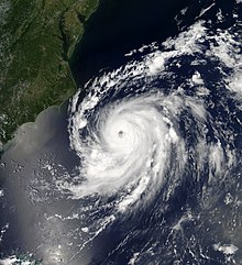
Hurricane Florence formed near Cabo Verde on August 31, steered toward the west-northwest with little exception by a large area of high pressure to its north.

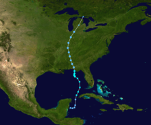
[4] In early October, Hurricane Michael formed in the western Caribbean Sea, resulting in significant flooding across Central America and Cuba.

However, the majority of the storm's impact was felt in the Florida Panhandle, where Michael struck the coastline near Mexico Beach as a Category 5 hurricane, with winds of 160 mph (260 km/h).

In addition, Michael became the third deepest by atmospheric pressure, the fourth strongest by maximum winds, and the latest Category 5 hurricane to strike the United States on record.

Additionally, figures for maximum sustained winds and position estimates are rounded to the nearest 5 units (knots, miles, or kilometers), following the convention used in the National Hurricane Center's products.

A track map of Tropical Storm Alberto
Storm path of Tropical Storm Alberto
Visible satellite imagery of a small but well-defined hurricane on July 6.
Hurricane Beryl on July 6
Visible satellite imagery of Hurricane Chris with a well-defined eye east of North Carolina on July 10.
Chris as an intensifying Category 1 hurricane on July 10
A track map of Tropical Storm Debby
Storm path of Tropical Storm Debby
A track map of Tropical Storm Ernesto
Storm path of Tropical Storm Ernesto
A visible satellite image of a tropical storm prior to making landfall near the Alabama–Mississippi border on September 4
Gordon shortly before landfall on September 4.
Visible satellite imagery of a large and fairly well organized hurricane in the eastern Atlantic on September 11.
Hurricane Helene on September 11
A track map of Hurricane Isaac
Storm path of Hurricane Isaac
A visible satellite imagery of an exceptionally well-defined and intense hurricane on September 11
Hurricane Florence at peak strength on September 11.
A track map of Tropical Storm Joyce
Storm path of Tropical Storm Joyce
A track map of Tropical Depression Eleven
Storm path of Tropical Depression Eleven
Visible satellite imagery of a strong tropical storm east of the Lesser Antilles on September 26.
Tropical Storm Kirk near peak intensity on September 26.
A track map of Hurricane Leslie
Storm path of Hurricane Leslie
Visible satellite imagery of Hurricane Michael as a Category 5 while making landfall in Florida on October 10
Michael moving ashore as a Category 5 hurricane on October 10
A track map of Tropical Storm Nadine
Storm path of Tropical Storm Nadine
Visible satellite imagery of an intense yet fairly asymmetric Hurricane Oscar on October 29
Oscar as an intensifying hurricane on October 29