Topography of Spain
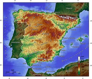
The topographical relief of Spain is characterized by being quite high, with an average altitude of 660 meters above sea level, quite mountainous compared to other European countries and only surpassed by Switzerland, Austria, Albania, Montenegro, North Macedonia and the microstates of Andorra and Liechtenstein.
The Pyrenees (in the northeastern limit) and the Baetic System (in the southeast) are the highest mountain ranges, located outside the Meseta Central.
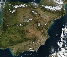
The Spanish coast, bathed by the Atlantic Ocean and the Cantabrian and Mediterranean Seas, has a great diversity of beaches, cliffs and rias.
The terrain is also influenced by the massive and not very articulated shape of the peninsula, the coasts lack projections and have a high average altitude.
From the Neogene period there have been three posthumous movements: the first one is the bulging of the plateau that tilts westward, derived from this, there are a series of thrusts from the east that cause the basement to also tilts towards the Atlantic, and the third phase is a series of movements of vertical origin that raise the alpine mountain ranges (Sistema Central and Montes de Toledo).
Finally, there are the morphogenetic systems that give rise to the current relief, referring to the climatic, erosive, chemical and mechanical aspects that affect the terrain and are linked to tectonics.
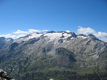
One form is the glacial cirque, a kind of circular depression under the influence of ice that occurs at higher altitudes and gives rise to a series of ice tongues called moraines that emerge from the highest part of the mountain and run through the valley to the base; if it fits between mountains and carves a valley in the shape of a "U" it is called a trough.
The Meseta Central is the main element of the terrain because it is located in the center of the country, occupies a large area and around it the mountain ranges and depressions are articulated.
The Spanish territory also presents a great natural and human diversity, which is given by the variety of the terrain and the climatic contrasts caused by it, which determine different types of vegetation, water and soil.
This is located in the center of the Iberian Peninsula, in the autonomous communities of Castilla y León, Madrid, Castilla-La Mancha, the eastern half of Extremadura and the southwest of Aragon, and is slightly inclined to the Atlantic Ocean.
The Submeseta Sur is located in the autonomous communities of Madrid, Castilla-La Mancha, in the eastern half of Extremadura and in the Aragonese province of Teruel.
At the southern limit of the Meseta Central is Sierra Morena, a mountain system that extends from west to east with a length of 400 km, making it the natural boundary of Castilla-La Mancha and Extremadura with Andalusia.
In the extreme northeast of the Iberian Peninsula are the Catalan Mediterranean System, a group of mountain chains located in the autonomous community of Catalonia.
In general terms it is rectilinear and is characterized by the abundance of cliffs, wave-cut platforms and short rias, the longest being the one of Bilbao, as well as by the scarcity of beaches and plains.
Further inland, marshes and dune fields abound as the terrain is very low (rarely exceeding 50 meters) and flat (the mouth of the Guadalquivir River occupies almost the entire territory).
Next to Cape Palos is the Mar Menor, a large saltwater lake separated from the Mediterranean Sea by a thin strip of land.
Between Cap de la Nau and the delta of the Ebro River is the Gulf of Valencia, characterized by having only beaches on its coast because the terrain is very flat.
The main elements of the Mediterranean coast, ordered from southwest to southeast, are: It presents an arc that spans the Cap de La Nao and ends in the salient of the Ebro delta.
The main elements of the Mediterranean coast, ordered from south to north, are: It stretches from the Ebro delta to Cap de Creus.
The relief of the Balearic Islands is dominated by flat, low-lying areas, except for the Sierra de la Tramontana, located in Mallorca.
The island has an elongated shape, oriented from north to south, with the ancient massifs of Famara and Los Ajaches at the ends, the intermediate plain being covered by recent volcanic material.
It has an area of 1659.71 km2 (the second largest of the archipelago) and a terrain characterized by smooth shapes in a territory modeled intensely by erosion, with little presence of recent volcanism.
On the coasts, cliffs abound (especially in the west) and the wave-cut platforms, with numerous coves at the mouth of the ravines and extensive beaches in the south.
The most outstanding relief element is the Caldera de Taburiente, a mountainous area whose peaks are arranged in the shape of a C, creating several valleys.
The terrain is marked by the presence of El Golfo, to the north, a bay formed by the collapse of part of the island building, with very steep ridges.
In the northeastern area is the Nisdafe plateau and to the west of the island there is a wide region with little ruggedness and numerous examples of recent volcanism.
The total land area is 52.5 ha, the terrain is rugged and rocky and the highest point is in the Cerro Nido de las Águilas, on the Isla del Congreso, with 137 m above sea level.
It must be taken into account that, until a little over two hundred years ago, access to many parts of the Iberian Peninsula was complicated because it was necessary to overcome mountain ranges.
The ancient Romans, the Visigoths, the Arabs and later the Christians had difficulties in conquering territories because the inhabitants of mountainous areas knew the orography of their land well, while the invaders did not.
On the other hand, this geography was one of the reasons why Spain did not have a sufficiently extensive railroad network until technologies allowed the construction of mountain routes.