Tornado vortex signature
[1] It may give meteorologists the ability to pinpoint and track the location of tornadic rotation within a larger storm, and is one component of the National Weather Service's warning operations.
Brown in the 1970s using experimental Doppler radar at the National Severe Storms Laboratory (NSSL) in Norman, Oklahoma.
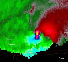
[4] In most cases, the TVS is a strong mesocyclone aloft, not an actual tornado, although the presence of an actual tornado on the ground can occasionally be inferred based on a strong couplet in concert with a tornadic debris signature (TDS) (i.e. a "debris ball" on reflectivity or certain polarimetric characteristics), or through confirmation from storm spotters.
Likewise, phenomena such as "fair-weather" waterspouts, landspouts, and gustnadoes, though cyclonic and occasionally damaging, do not normally produce a signature identifiable by a TVS.
[6] Rotation associated with quasi-linear convective systems (QLCSs) or squall lines can trip the TVS but do so less reliably as the couplets typically are more transient, are shallower, smaller, and weaker.