Convective storm detection
[1] The ability to discern the presence of deep moist convection in a storm significantly improves meteorologists' capacity to predict and monitor associated phenomena such as tornadoes, large hail, strong winds, and heavy rain leading to flash flooding.
Some in situ measurements are used for direct detection as well, notably, wind speed reports from surface observation stations.
It is part of the integrated warning system, consisting of prediction, detection, and dissemination of information on severe weather to users such as emergency management, storm spotters and chasers, the media, and the general public.
The organizations forward the reports to their NWS Weather Forecast Office (WFO) who in turn directly issue information and warnings through its NOAA Weather Radio All Hazards network and other channels, resulting in further distribution over the Emergency Alert System and Wireless Emergency Alerts, and the activation of sirens.
[8] Radar and satellite data interpretation will usually give a warning before there is any visual evidence of such events, but ground truth from an observer can either verify the threat or determine it is not imminent.
[11] Today, most developed countries have a network of weather radars, which remains the main method of detecting signatures likely associated with tornadoes and other severe phenomenons as hail and downbursts.
In short-term prediction and detection of tornadoes, meteorologists integrate radar data with reports from the field and knowledge of the meteorological environment.
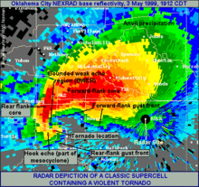
An early step in a storm organizing into a tornado producer is the formation of a weak echo region (WER) with a tilted updraft.
A BWER is found near the top of the updraft and nearly or completely surrounded by strong reflectivity, and is indicative of a supercell capable of cyclic tornadogenesis.
In reflectivity (precipitation intensity) data, a tight echo gradient (particularly on the inflow area) and a fan shape generally indicate a supercell.
A supercell is characterized by a mesocyclone, which is usually first observed in velocity data as a tight, cyclonic structure in the middle levels of the thunderstorm.
TVS is then an extremely strong mesocyclone found at very low level and extending over a deep layer of the thunderstorm, not the actual tornadic circulation.
After the implementation of the WSR-88D network in the U.S., the probability of detection of tornadoes increased substantially, the average lead time rose from four minutes to thirteen minutes, and a 2005 NOAA report estimates that as a result of improved warnings that there are 45 percent fewer fatalities and 40 percent fewer injuries annually.
Dual-polarization radar, being implemented to the US NEXRAD network,[12] may provide enhanced warning of tornadoes and severe winds and hail associated with the hook echo due to distinct precipitation drop characteristics.
S. R. Stewart, from NWS, has published in 1991 an equation relating VIL and the echo tops that give the potential for surface gust using this concept.
With the Doppler velocity data, the meteorologist can see the downdraft and gust fronts happening, but since this a small scale feature, detection algorithms have been developed to point convergence and divergence areas under a thunderstorm on the radar display.
Most populated areas of the earth are now well covered by weather satellites, which aid in the nowcasting of severe convective and tornadic storms.
Meteorologists can extract information about the development stage and subsequent traits of thunderstorms by recognizing specific signatures in both domains.
Sensors on satellites can also detect emissions from water vapor (WV: 6-7 μm), but mostly in the middle to upper levels of the troposphere, so thunderstorms are only seen after being well developed.
It is, however, useful in convective storm prediction, as it illustrates the placement and movement of air masses and of moisture, as well as shortwaves and areas of vorticity and lifts.
The rising air parcels in that column accelerate and will overshoot the equilibrium level (EL) before being pulled back by negative buoyancy.
This mesoscale front, when moving into a warm and unstable air mass, will lift it and cumulus clouds appear on satellite pictures.
[22] One can notice it at the leading edge of a squall line, in the southeastern quadrant of a typical supercell (in the northern hemisphere), or different regions around other thunderstorms.
They may also be visible as an outflow boundary hours or days after convection and can pinpoint areas of favored thunderstorm development, the possible direction of movement, and even likelihood for tornadoes.
Fast-moving gust fronts may eventually decelerate and become slow-moving or stationary outflow boundaries with the characteristic "agitated area" of cumulus fields previously mentioned.
Lightning data is useful in suggesting intensity and organization of convective cells as well trends in thunderstorm activity (particularly growth, and to a lesser degree, decay).
In addition, lightning prediction systems are available and used mostly by parks and other outdoor recreational facilities, or meteorologists contracted to provide weather information for them.