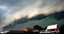
Squall line
Linear thunderstorm structures often contain heavy precipitation, hail, frequent lightning, strong straight-line winds, and occasionally tornadoes or waterspouts.
On the back edge of the rainband associated with mature squall lines, a wake low can be present, on very rare occasions associated with a heat burst.
Polar front theory was developed by Jacob Bjerknes, derived from a dense network of observation sites in Scandinavia during World War I.
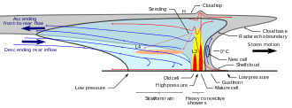
The resultant mesoscale convective system (MCS) forms at the point of the upper level split in the wind pattern in the area of best low-level inflow.
When the convection is strong linear or curved, the MCS is called a squall line, with the feature placed at the leading edge of the significant wind shift and pressure rise.
[3] Well behind mature squall lines, a wake low can develop on the back edge of the rain shield,[4] which can lead to a heat burst due to the warming up of the descending air mass which is no longer being rain-cooled.
As supercells and multi-cell thunderstorms dissipate due to a weak shear force or poor lifting mechanisms, (e.g. considerable terrain or lack of daytime heating) the gust front associated with them may outrun the squall line itself and the synoptic scale area of low pressure may then infill, leading to a weakening of the cold front; essentially, the thunderstorm has exhausted its updrafts, becoming purely a downdraft dominated system.
From here, a general thinning of a squall line will occur: with winds decaying over time, outflow boundaries weakening updrafts substantially and clouds losing their thickness.
In low to medium shear environments, mature thunderstorms will contribute modest amounts of downdrafts, enough to help create a leading edge lifting mechanism – the gust front.
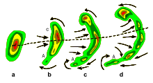
A LEWP is a special configuration in a line of convective storms that indicates the presence of a low-pressure area and the possibility of damaging winds, large hail, and tornadoes.
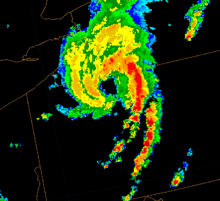
)[10] In addition, they have a distinctive appearance on radar (bow echo); several unique features, such as the rear inflow notch and bookend vortex, and usually manifest two or more downbursts.