Tornadoes of 2012
These included an EF2 on June 4 that caused three fatalities in Diehlstadt, Missouri, and a small outbreak in Florida associated with Tropical Storm Debby that killed one person.
August and September were also generally very quiet as well, broken only by an active period after Hurricane Isaac made landfall, producing a sizable multi-day tornado outbreak.
Along the eastern side of this system, warm, moist air from the Gulf of Mexico was drawn northward and created an environment favoring supercell thunderstorms, though widespread clouds limited the extent of activity.
[7] Developing into an upper-level system over the Ark-La-Tex region on January 10, the risk for more widespread severe weather was evident; however, only isolated reports were received that day.
On January 22, the Storm Prediction Center issued a moderate risk for severe weather across parts of the Southern United States and Ohio Valley.
Two separate tornadoes, rated EF2 and EF1, caused considerable damage to metal truss towers, outbuildings, trees, and power poles near De Witt.
Overnight and into the very early morning hours, another round of discrete supercell activity developed ahead of the squall line as the storms pushed into Alabama.
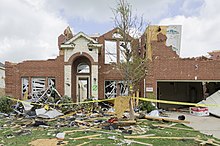
This tornado touched down near Tarrant before tearing through Center Point, Chalkville, and Clay, killing one person and destroying hundreds of homes and businesses.
A violent EF4 tornado touched down and ripped through the city of Harrisburg, destroying entire neighborhoods, flattening businesses, and killing 8 people before causing additional destruction in the neighboring town of Ridgway.
A moderate risk of severe weather was issued for March 2 a day in advance for a large area from near Tuscaloosa, Alabama, to Dayton, Ohio, as an intense storm system tracked across the region in a very highly sheared and unstable environment.
For only the second time in history (the first being April 27, 2011, for the 2011 Super Outbreak), Dr. Greg Forbes, severe weather expert for The Weather Channel, issued a TOR:CON (short for "tornado condition index", a scale to rate the risk of tornadic activity over a given region based on atmospheric conditions) rating of 10 out of 10; this time for the Louisville, Kentucky region and along the Ohio River of Indiana and Kentucky.
A long-lived EF4 formed just north of the Ohio River that afternoon, resulting in extreme damage to numerous communities in southern Indiana, including Marysville and Henryville.
"[24][25] In addition to the spectacular early-morning lightning storms and flooding from the four feet (3.3 meters) of rainfall received, a tornadic waterspout formed off the coast of Oahu during the morning of March 9, 2012.
This mesocyclone-induced waterspout tracked inland for 1.5 miles, becoming an EF0 tornado that caused minor damage to the Enchanted Lakes subdivision of Kailua at 7:10 am Hawaiian-Aleutian Time.
[26] As a weak disturbance moved across the Ohio Valley, energy associated with the system, combined with abnormally warm temperatures, led to the formation of severe thunderstorms from Michigan to the Gulf States, where the Storm Prediction Center had already issued a Slight risk.
As the day progressed, isolated thunderstorms began to form and quickly strengthened into tornado-producing cells across the state of Michigan, with Tornado Warnings being issued for Lenawee, Washtenaw, Lapeer, and Monroe Counties.
[20] An impressive low pressure area and associated trough began tracking into the Great Plains on April 13, and a slight risk of severe weather was issued.
As this supercell moved into Wichita around 10:15 pm CDT (0315 UTC), another large EF3 wedge tornado touched down and caused major damage in the southeastern part of the city.
[43] Around 10:00 p.m. CDT (0300 UTC), a broken squall line began to form across the eastern portions of the Texas and Oklahoma panhandles; a thunderstorm developed ahead of the northern line segment in northwestern Wheeler County, Texas, at approximately 10:30 p.m. CDT (0330 UTC), and began developing supercell characteristics as it tracked northeastward into the Oklahoma counties of Ellis and Roger Mills.
A large EF2 was documented by numerous storm chasers as it passed near the town of La Crosse, causing significant damage to farmsteads, outbuildings, and trees.
Alabama, Mississippi, Arkansas, Missouri, Illinois, Indiana, Delaware, and New Jersey all recorded several, mostly weak, tornadoes until the remnants of Isaac moved away from the United States.
[64] The storms were associated with a vigorous low pressure system that spawned severe weather across New England, Pennsylvania, New York as well as across the Canada–US border into southern Ontario and Quebec.
Farther east, an EF2 tornado tracked through areas near Shelby, Mississippi, downing a radio tower and destroying a mobile home, along with several outbuildings.
Tornado activity continued into the early morning hours of October 18, including an EF3 that passed near Forest, Mississippi, downing countless trees, destroying mobile homes and outbuildings, and bending three large metal high-tension poles to the ground.
The first was a large F3 stovepipe tornado that struck Barlewiczki, heavily damaging or destroying homes, barns, and businesses, downing many trees and power poles, tossing farm implements, and injuring several people before dissipating.
A second F3 tornado impacted the Wycinki area, completely flattening a massive swath of trees in the Bory Tucholskie National Park and damaging or destroying multiple homes.
Multiple industrial buildings at the Ilva steel plant were severely damaged, a large reinforced concrete chimney was completely destroyed, and a massive multi-ton crane was lifted and toppled at this location.
The strongest tornado to occur that day was an F2 that touched down near Katakolo and uprooted hundreds of olive trees, and also destroyed the roofs of several structures, along with some metal shelter buildings.
[96][97] On May 6, a powerful and destructive high-end F3 tornado tracked through the town of Tsukuba, Ibaraki roughly 40 mi (64 km) away from Tokyo, Japan, killing one person and injuring thirty-seven others.
[103] Diego Santilli, the minister of the Argentine Ministry of Environment and Public Space, stated that these storms were the result of climate change, and an ongoing "tropicalization of Buenos Aires.