Tropical Storm Debby (2012)
The fourth tropical cyclone and named storm of the 2012 Atlantic hurricane season, Debby developed from a trough of low pressure in the central Gulf of Mexico on June 23.
Despite a projected track toward landfall in Louisiana or Texas, the storm headed the opposite direction, moving slowly north-northeast and northeastward.
The storm slowly strengthened, and at 1800 UTC on June 25, attained its peak intensity with maximum sustained winds of 65 mph (100 km/h).
Coinciding with a Madden–Julian oscillation, a weak surface low pressure area developed on June 19, and subsequently moved inland over the Yucatán Peninsula.
Located in the southeastern Gulf of Mexico, moderate vertical wind shear caused the system to remain disorganized.
Thus, it is estimated that Tropical Storm Debby developed at 1200 UTC on June 23, centered about 290 miles (470 km) south of mouth of the Mississippi River.
[6] The forecast track for Debby was shifted significantly to the east late on June 24, and it was predicted that the storm would move northward and make landfall near Panama City, Florida.
[7] Based on a dropsonde estimate, Debby attained its minimum barometric pressure of 990 mbar (29 inHg) at 0000 UTC on June 25.
However, the storm began to weaken due to increasing wind shear, drier air, and upwelling of cold water, caused by Debby's slow movement.
[8] Due to its excessively slow movement and no prediction for acceleration, the National Hurricane Center remarked that, "the cyclone does not seem to be going anywhere anytime soon.
The storm weakened quickly after moving inland, and by early on June 27, it was downgraded to a tropical depression, while located about 35 miles (56 km) north of Gainesville, Florida.
Debby maintained tropical cyclone status while crossing Florida, but degenerated into a trough of low pressure by 1800 UTC on June 27.
[1] In the final advisory issued by the National Hurricane Center three hours later, the agency noted that Debby could eventually reacquire tropical characteristics.
[10] After its dissipation, however, the remnants did not regenerate into a tropical cyclone, but re-developed a new center of circulation and strengthened slightly due to baroclinic conditions.
As it accelerated northward, Debby's remnants became increasingly frontal in nature, and once again degenerated into an open trough at 1800 UTC on June 30; at this time, the disturbance was located south of Newfoundland.
[1] Upon development of Debby on June 23, a tropical storm warning was issued from the mouth of the Pearl River to Morgan City, Louisiana, excluding New Orleans or Lake Pontchartrain.
On the following day, a separate tropical storm warning was put into effect from the Mississippi and Alabama border to the mouth of the Ochlockonee River in Florida.
According to the Federal government of the United States, nearly 25% of crude oil and natural gas production in the Gulf of Mexico was shut down.
[11] On June 24, voluntary evacuations were issued for several areas in northwest Florida during the approach of the storm, especially Taylor and Wakulla Counties.
[13] Additionally, mandatory evacuations were issued for St. George Island,[14] Alligator Point, and other low-lying areas of Franklin County.
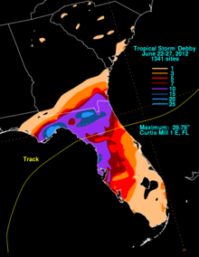
[1] Throughout June 25, an intense complex of thunderstorms developed to the north of Debby's center and produced torrential rains over the Florida Panhandle for much of the day.
[1] Rainfall caused numerous small creeks, streams, and rivers to rapidly exceed their banks and flood adjacent communities.
In Dixie County, several roads north of Cross City experienced flooding, while water entered at least 40 homes along the Steinhatchee River.
[15] In Columbia County, preliminary losses were placed in excess of $20 million as of July 3 and did not take into account hundreds of homes that remained flooded at the time.
A second tornado in the county later that day broke light poles and snapped tree limbs in North Naples, with one person being injured by a falling branch.
[30] The Charlotte County Airport recorded a 55 mph (89 km/h) wind gust, while the highest rainfall total was 5.25 inches (133 mm) near Englewood.
The other twister in Palm Beach County snapped some trees, blew a gate across a street, and broke a railroad crossing arm.
A waterspout offshore Miami-Dade County moved inland near Golden Beach and twisted three gates and blew open a garage door.
[15] The remnants of Debby passed about 90 miles (140 km) north of Bermuda on June 29 and produced tropical storm force winds on the island, but caused no damage.
[1] Following the storm, U.S. President Barack Obama issued a disaster declaration for Baker, Bradford, Citrus, Clay, Columbia, Duval, Franklin, Gilchrist, Hernando, Highlands, Hillsborough, Lafayette, Manatee, Nassau, Pasco, Pinellas, Polk, Sarasota, Suwannee, Taylor, Union, and Wakulla Counties of Florida.

Tropical storm (39–73 mph, 63–118 km/h)
Category 1 (74–95 mph, 119–153 km/h)
Category 2 (96–110 mph, 154–177 km/h)
Category 3 (111–129 mph, 178–208 km/h)
Category 4 (130–156 mph, 209–251 km/h)
Category 5 (≥157 mph, ≥252 km/h)
Unknown