Transport in Auckland
[3] The use of public transport in Auckland was high until the 1950s but subsequently declined during the second half of the 20th century,[4] before experiencing a strong resurgence from the early 2000s.
[5] With the motorway network now largely completed,[6] major efforts are underway to increase public transport use to address Auckland's congestion.
Māori hauled waka (canoes) between the harbours at portages, short traversable sections of land that connected the bodies of water.
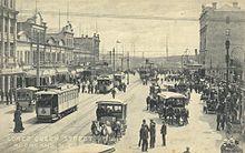
The overcrowding of the inner city eventually created a demand for expansion made viable when new transportation technology appeared around 1900 in the form of streetcars (trams) and railways arriving in Auckland.
As the system grew, it facilitated the expansion of Auckland's built-up area in two ways: in an intermittent linear pattern to the west and south along the railway line, and in a more continuous manner along the main routes.
[17] Expansion of the railway network facilitated growth in more distant locations such as Ōtāhuhu and New Lynn, while ferries served Devonport, Takapuna and Birkenhead on the North Shore.
However, this situation was not to last for long, as even before the Second World War the car was becoming an integral part of life for many New Zealanders, opening up previously unreachable land for development.
[19] This growing popularity meant that urban development could break free from the constraints of transport networks and occur anywhere roads were built.
Continued strong population growth, combined with cheaper car imports, led to growing traffic congestion across much of Auckland in the 1990s and early 2000s.
[22] In response to growing congestion, central and local government increased transport investment from around $500 million a year in 2000 to over $2 billion in 2015.
Despite these improvements, rapid population growth means that transport is still a major challenge for Auckland, with congestion costing the city around $1.3 billion a year.
To best balance their wide variety of different functions, at peak times some roads have bus or carpool lanes,[36] while on-street parking is frequently restricted.
Major pieces of infrastructure include: Providing new roading connections in Auckland, or widening existing corridors, is becoming increasingly difficult and expensive.
Major roading projects currently planned or proposed include: Public transport in Auckland consists of bus, ferry and commuter rail services.
Frequent long-distance services, principally operated by Intercity and its subsidiary Newmans, link Auckland with all the main centres throughout the North Island.
Since the early 2000s, there has been a substantial increase in services, with trains now operating every 10 minutes on the Western, Southern and Eastern lines at peak times.
A number of North Shore commuters who work in the Auckland CBD catch ferry services from Devonport, Stanley Bay, Bayswater, Beach Haven or Birkenhead.
A new runway is planned north of the main airport area, with a shorter length well suitable for the booming intra-New Zealand flight market.
A Royal New Zealand Air Force facility at Hobsonville has been vacated and is currently under redevelopment primarily as a residential area, although some light commercial and industrial uses (for example super-yacht building) are present.
[53] AT partners with community organisations to operate 10 'Bike Hubs' in the city to repair, refurbish and sell bikes as well as provide advice and information.